
LiDAR Drone Payloads and System for Survey – Camera Included
LiDAR (Light Detection and Ranging) drones have a wide range of applications across various industries due to their ability to accurately capture 3D data and provide detailed information about the surrounding environment. Some of the common applications for LiDAR drones include Surveying and Mapping, Forestry Management, Environmental Monitoring, Mining and Quarrying, Construction and Civil Engineering, Infrastructure Inspection, Flood Modelling and Management, Archaeology and Cultural Heritage, and Wildlife Conservation, etc.
The versatility and precision of LiDAR technology makes it a valuable tool in a wide range of industries, enabling more efficient data collection, analysis and decision-making.
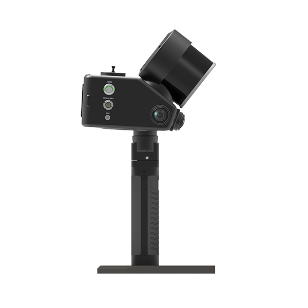
Entry-Level LiDAR drone payloads
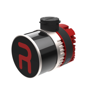
Key Features
Ultra-Lightweight & Compact Design – Weighing only 1.2 kg, it is the lightest complete payload offered by Inertial Labs that integrates both LiDAR and camera technology, making it ideal for SUAS integrators and platforms with volume constraints.
SnapFit Adapter System – Features quick plug-and-play SnapFit adapters for seamless integration with various platforms, including Freefly, WISPR, DJI, Sony, and mobile platforms, allowing for rapid mounting and dismounting.
Cost-Effective & High-Performance – Positioned as the most affordable comprehensive solution released, it delivers exceptional value without compromising on data accuracy and precision.
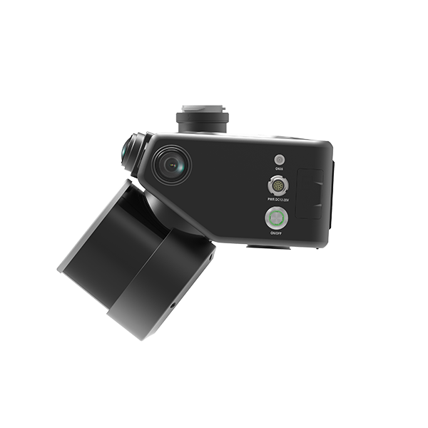
High-Precision LiDAR with Zero-Blind Range – The XT-32 LiDAR scanner offers a range precision of 0.5 cm and accuracy of ±1 cm. It features a unique zero-blind range capability, allowing point cloud data to be collected even when objects are touching the sensor enclosure.
Multi-Mode Operations – Versatile enough to support aerial scanning, pedestrian hand-held SLAM operations, and vehicle-mounted mobile mapping, making it an all-in-one solution for diverse surveying needs.
Embedded Colorization Camera – Includes a built-in 5MP camera for point cloud colorization.
High Reliability – The XT-32 LiDAR has passed over 50 reliability tests under international OEM standards and is designed for a lifetime of over 30,000 hours of typical usage.
Comprehensive Software Suite (PCMasterPro) – Supports field checks, pre-processing, post-processing, SLAM (powered by Kudan), and strip alignment (powered by BayesMap), along with coordinate system transformation, batch processing, noise filtering, and more.
Key Specifications
| Category | Specification | Detail |
|---|---|---|
| System | Weight | 1.2 kg |
| Dimensions | 13.1 × 11.2 × 10.3 cm | |
| Vertical Accuracy | 2 – 3 cm | |
| Precision (1σ Noise Removal) | 1.5 – 2.5 cm | |
| Recommended AGL | 100 m | |
| Max Flight Time (DJI M350) | 35 minutes | |
| External Storage | 256 GB (USB) | |
| System Computer | Quad-core, 1GB RAM, 8GB eMMC | |
| Operational Voltage Range | 9 – 45 V | |
| Power Consumption | 20 W | |
| LiDAR Scanner | Model | XT-32 |
| Laser Channels | 32 | |
| Range Capabilities | 0.05 to 120 m 80 m @ 10% reflectivity (channels 9-24) 50 m @ 10% reflectivity (channels 1-8, 25-32) | |
| Range Accuracy | ± 1 cm | |
| Horizontal FOV | 360° | |
| Vertical FOV | 31° (-16° to 15°) | |
| Beam Divergence | 0.021° (H) / 0.047° (V) | |
| Number of Returns | 2 | |
| Pulse Rate | 640k/s (single return) / 1,280k/s (dual return) | |
| Camera | Resolution | 5 MP |
| Lens | Fixed, Manual Focus | |
| Max Trigger Rate | 2 seconds | |
| Field of View | HFOV = 70.8°, VFOV = 55.6° | |
| GPS-Aided INS | IMU | Inertial Labs KERNEL-210 |
| GNSS Receiver | NovAtel OEM7500 | |
| Constellations | GPS, GLONASS, Galileo, BeiDou, QZSS, SBAS, L-Band | |
| Frequencies | L1, L1C, L2, L2C, B1, B2, E1, E5b | |
| Operation Modes | RTK and PPK | |
| INS Algorithm | Extended Kalman Filter | |
| Output Rates | Up to 200 Hz (INS) / Up to 2,000 Hz (IMU) | |
| Pitch/Roll Accuracy | 0.03° (RTK) / 0.004° (PPK) | |
| Heading Accuracy | 0.1° (RTK) / 0.02° (PPK) | |
| Position Accuracy | 1 cm + 1 ppm (RTK) / 0.5 cm (PPK) | |
| Software | Control & Processing | PCMasterPro |
Key Features
Lightweight & Compact Design – Weighing only 1.2 kg (airborne unit) with rugged, integrated construction, it features a simple one-touch operation interface for maximum field efficiency.
Real-Time Terrain Following – Supports real-time DEM construction for terrain-following flight, meeting the demands of large-elevation-difference terrain data collection with a short-range LiDAR system.
Upgraded High-Resolution Camera with Video Streaming – Equipped with a 26 MP APS-C mapping camera that supports 720P/30 FPS real-time video transmission to the GreenValley APP. This allows flight personnel to clearly view powerline trends and the surrounding environment during inspection missions.
GreenValley APP for Real-Time Control – The APP supports real-time point cloud display, parameter adjustment, and status monitoring. It can be installed directly on DJI M300/M350 RTK remote controllers for enhanced on-site situational awareness.
Support Handheld Mode (Air-Ground Integration) – An optional handheld kit (weighing just 0.68 kg) enables ground-based SLAM scanning. It fuses GNSS and LiDAR SLAM algorithms, allowing seamless operation from aerial (with GNSS) to indoor (GNSS-denied) environments with centimeter-level data fusion accuracy.
GNSS Antenna-Free Solution – When mounted on DJI M300/M350 RTK aircraft, no external GNSS antennas are required, simplifying installation while still achieving centimeter-level post-processed point clouds.
High-Efficiency & Multi-Scenario Operation – Delivers 3–5 cm absolute accuracy with a point density better than 10,000 pts/m² and an effective range of 190 m (10% reflectivity). Operational efficiency reaches up to 100,000 m² per hour. Suitable for forestry, mining surveying, power line monitoring, building facade scanning, and more.
Handheld Accessory Highlights – Lightweight (0.68 kg), ergonomic grip, quick-release design, and a battery box providing up to 55 minutes of continuous operation. SLAM technology ensures accurate positioning even in signal-blocked areas.
Key Specifications
| Category | Specification | Detail |
|---|---|---|
| System | Weight (Airborne) | 1.2 kg |
| Dimensions | 136 × 106 × 131 mm | |
| Vertical Accuracy | 5 cm @ 70 m | |
| Detection Range | 190 m @ 10% reflectivity 450 m @ 80% reflectivity | |
| Typical Flight Speed | 5 – 10 m/s | |
| Operating Voltage | 12 – 24 V DC (0.75 A @ 24V) | |
| Power Consumption | 18 W | |
| Internal Storage | 256 GB TF Card | |
| Operating Temperature | -20°C to 50°C | |
| Storage Temperature | -30°C to 60°C | |
| LiDAR Sensor | Wavelength | 905 nm |
| Laser Class | Class 1 (Eye-safe) | |
| Range Accuracy | 2 cm (1σ @ 20 m) | |
| Field of View (FOV) | 70.4° (Horizontal) × 4.5° (Vertical) | |
| Scan Rate | 720,000 pts/s (Triple Return) | |
| Number of Returns | 3 | |
| Scan Method | Repetitive Scan | |
| Inertial Navigation System | GNSS Support | GPS, GLONASS, Galileo, BDS |
| Attitude Accuracy (Roll/Pitch) | 0.008° | |
| Azimuth (Heading) Accuracy | 0.038° | |
| IMU Data Frequency | 200 Hz | |
| Camera | Image Sensor | APS-C |
| Resolution | 26 MP | |
| Image Resolution | 6252 × 4168 | |
| Focal Length | 16 mm (24 mm equivalent) | |
| Handheld Accessories | Handheld Weight (incl. base) | 0.68 kg |
| Handheld Dimensions | 181.8 × 108 × 88 mm | |
| Battery Box Weight | 0.81 kg | |
| Battery Capacity | 5870 mAh | |
| Continuous Operation Time | Max 55 minutes | |
| Applicable Environment | Indoor & Outdoor | |
| Software | Control Software | GreenValley |
| Pre-Processing | LiGeoreference | |
| Post-Processing | LiDAR360 / LiPowerline (Optional) | |
| Data Output | Mapping Principle | SLAM, PPK-SLAM |
| Real-Time Calculation | Not Supported | |
| Absolute Accuracy | ≤ 5 cm | |
| Point Cloud Formats | LAS, LiData |
Medium-Range LiDAR Drone Payloads
Medium range drone LiDARs may be slightly more expensive than entry level, however, they are equipped with high performance INS which can deliver point cloud with higher accuracy.
INS (Inertial Navigation System) is critical for a drone LiDAR scanner system, because it provides the necessary positional accuracy, data registration and reliability, especially in challenging environments. It ensures that the LiDAR data collected is accurate, coherent and geo-referenced, making it a critical component for various applications such as surveying, mapping and infrastructure inspection.
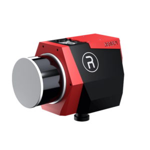
Key Features
- Next-Generation Multi-Platform Sensor Fusion – A state-of-the-art sensor fusion platform designed for high-precision real-time and post-processed remote sensing, versatile enough for aerial, mobile (vehicle), handheld (RESEPI backpack), and pedestrian applications.
- Enhanced LiDAR Scanning Module – Features the upgraded XT-32M2X LiDAR scanner, which is lighter and offers a longer detection range than previous generations, improving flight time and area coverage.
- High-Performance Core Components – Integrates the Inertial Labs dual-antenna INS-D, the tactical-grade Kernel-210 IMU, and a NovAtel OEM7720 GNSS receiver to ensure highly accurate data collection.
- Superior Onboard Computing & Expandability –
Equipped with a powerful onboard computer supporting real-time point cloud visualization.
Supports integration and synchronization with external sensors (additional cameras, LiDAR, GNSS receivers, odometry/wheel sensors).
Supports MAVLink and DJI Payload SDK (PSDK) for seamless platform integration.
High-Resolution Camera Options – Offers new camera options with a wider field of view, faster shutter speeds, and higher resolution (e.g., the 61MP Sony ILX-LR1 camera).
“SnapFit” Smart Adapter System – Enables plug-and-play integration with major UAV platforms, including DJI M300/M350, Freefly Astro, Sony Airpeak S1, and WISPR Sky Scout.
Comprehensive Post-Processing Software – Bundled with PCMasterPro software, which supports field inspection, pre-processing, and post-processing, integrating Kudan SLAM algorithms and BayesMap strip alignment capabilities.
Key Specifications
| Specification | Detail |
|---|---|
| System Accuracy & Weight | |
| Vertical Accuracy | 2 – 3 cm |
| Precision (1σ noise removed) | 1.5 – 2.5 cm |
| Recommended Flight Height (AGL) | 150 m |
| System Weight | 1.7 kg |
| Dimensions | 21.6 x 17.8 x 13 cm |
| Max Flight Time (on DJI M300) | 33 minutes |
| Internal Storage | 512 GB SSD |
| Onboard Computer | Hexa-core, 8GB DDR4 RAM, 16GB eMMC |
| Operating Voltage Range | 9 – 50 V |
| Power Consumption | 40 W |
| LiDAR Scanner | |
| Laser Channels | 32 |
| Ranging Capability | 0.05 to 300 m (80 m @ 10% reflectivity) |
| Ranging Accuracy | ± 1 cm |
| Horizontal FOV | 360° |
| Vertical FOV | 40.3° (-20.8° to 19.5°) |
| Pulse Emission Rate | 640k/s (single return) / 1,280k/s (dual return) / 1,920k/s (triple return) |
| Number of Returns | 3 |
| Camera | |
| Model | Sony ILX-LR1 |
| Resolution | 61 MP |
| Lens | Fixed focal length, manual focus, 18 mm |
| Field of View | 100° |
| GPS-Aided Inertial Navigation System (INS) | |
| IMU | Inertial Labs Kernel-210 |
| GNSS Receiver | NovAtel OEM7720 |
| Supported Constellations | GPS, GLONASS, Galileo, BeiDou, QZSS, NavIC, SBAS, L-Band |
| Operating Modes | RTK and PPK |
| Attitude Accuracy (Roll/Pitch) | 0.03° (RTK) / 0.004° (PPK) |
| Heading Accuracy | 0.08° (RTK) / 0.02° (PPK) |
| Position Accuracy | 1 cm + 1 ppm (RTK) / 0.5 cm (PPK) |
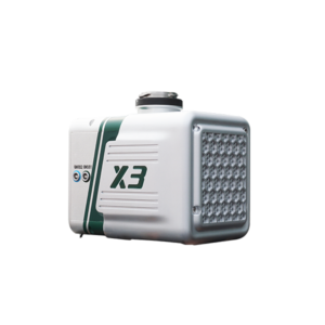
Key Features
Lightweight & Long-Range Design – Weighing only 1.62 kg with a maximum range of 1,200 m, it is compatible with light-wing and multi-rotor UAVs (including DJI M300/M350 RTK/M400), significantly improving flight endurance and operational efficiency.
High-Precision Survey-Grade Data – Delivers elevation accuracy better than 5 cm and point cloud thickness under 3 cm at a 200 m operating altitude, ensuring high-quality terrain reconstruction.
Excellent Vegetation Penetration – Uses a small laser spot with concentrated pulse energy and unlimited returns, enabling effective penetration through dense vegetation to capture complete sub-canopy terrain data.
Adaptive Parameter Configuration – Offers 7 preset configurations for flight height, pulse repetition rate, and laser energy, ensuring uniform point cloud distribution (consistent scan line and point spacing) across varying flight conditions for detailed 3D reconstruction.
Intelligent Flight Control – When integrated with DJI M300/M350 RTK/M400 drones, it features automatic data collection start/stop (based on takeoff/landing) and intelligent height detection, minimizing data redundancy and improving post-processing efficiency.
Real-Time Monitoring with GreenValley Flight Assistant – Supports real-time 3D point cloud display, operational status monitoring, and device parameter configuration, allowing field crews to verify data integrity instantly and prevent ineffective operations.
One-Stop Software Ecosystem – Bundled with GreenValley flight control software, LiGeoreference for pre-processing, and optional LiDAR360 / LiPowerline for advanced post-processing (power line inspection, forestry, emergency response).
Key Specifications
| Category | Specification | Detail |
|---|---|---|
| System | Vertical Accuracy | ±5 cm @ 200 m |
| Weight | 1.62 kg | |
| Dimensions | 217 × 88 × 106.4 mm | |
| Storage | 256 GB TF Card | |
| Operating Voltage | 18–24 V DC (2.52 A @ 24 V) | |
| Typical Power Consumption | Approx. 50 W | |
| Communication Interfaces | WiFi / USB-C | |
| Operating Temperature | -20°C to 50°C | |
| Storage Temperature | -30°C to 60°C | |
| LiDAR Sensor | Max Range | 450 m @ 10% reflectivity 1,000 m @ 50% reflectivity 1,200 m @ 80% reflectivity |
| Wavelength | 1550 nm (eye-safe) | |
| Horizontal Field of View (FOV) | 80° | |
| Range Precision | 5 mm @ 100 m | |
| Number of Returns | Unlimited | |
| Scan Rate | 90 – 300 lines/sec | |
| Pulse Repetition Rate | Up to 1,000 kHz (1,000,000 pts/sec) [text states max; table lists 100,000–100,000 pts/sec, likely a typo] | |
| Inertial Navigation System (INS) | GNSS Support | GPS, GLONASS, Galileo, BDS (BeiDou) |
| Attitude Accuracy (Roll/Pitch) | 0.006° | |
| Azimuth (Heading) Accuracy | 0.019° | |
| IMU Data Frequency | 500 Hz | |
| Camera | Resolution | 26 MP |
| Image Resolution | 6252 × 4168 | |
| Focal Length | 16 mm (24 mm equivalent) | |
| Software | Control Software | GreenValley |
| Pre-Processing | LiGeoreference | |
| Post-Processing | LiDAR360 / LiPowerline (Optional) |
Key Features
Highly Intelligent Autonomous Flight – Retains autonomous flight capabilities specifically designed for powerline inspection. Features include automatic line intersection identification and crossing, real-time tree obstacle reporting, automated pole/tower logging, and terrain-following flight modes for large-area data collection with short-range LiDAR systems.
Multi-Mode Operation (Airborne/Handheld/Backpack) – Supports rapid switching between airborne, handheld, and backpack configurations. In handheld mode, the built-in SLAM algorithm delivers high-precision point clouds with thickness <2 cm, enabling centimeter-level integration of aerial and terrestrial data.
Integrated Aerial-Terrestrial Workflow & 3DGS Support – Equipped with triple 12MP panoramic cameras alongside the 26MP mapping camera. By fusing airborne/handheld point clouds with high-resolution panoramic imagery, it supports large-scale, high-fidelity 3D Gaussian Splatting (3DGS) models for complete and detailed scene reconstruction.
Omnidirectional Obstacle Avoidance – Features directional scanning with a high-precision integrated motor, detecting obstacles in real time and automatically choosing climbing or bypass strategies to ensure flight safety with minimal manual intervention.
Antenna-Free GNSS Solution – When mounted on DJI M300/M350 RTK drones, it requires no external GNSS antennas yet still acquires high-precision GNSS information, simplifying setup while achieving centimeter-level post-processed point clouds.
GreenValley APP for Real-Time QC – Provides real-time point cloud display and RTK data acquisition in both airborne and handheld modes, delivering absolute coordinate point clouds for timely surveys. Additionally, 720p/30fps video streaming enables clear field monitoring, enhancing operational control and safety.
Compact, Integrated Design – Internal integration of the panoramic camera module results in a more compact form factor compared to its predecessor, with faster switching times and a lightweight build.
Key Specifications
| Category | Specification | Detail |
|---|---|---|
| System | Weight | 1.6 kg |
| Dimensions | 208 × 120 × 184 mm | |
| Internal Storage | 256 GB TF Card + 512 GB Internal SSD | |
| Operating Voltage | 12 – 28 V | |
| Power Consumption | 36 W | |
| Operating Temperature | -20°C to 50°C | |
| Storage Temperature | -30°C to 60°C | |
| Typical Flight Speed | 10 m/s | |
| Performance Accuracy | Vertical Accuracy (Airborne) | <5 cm @ 100 m |
| Handheld Absolute Accuracy | <5 cm | |
| Handheld Point Cloud Thickness | <2 cm | |
| LiDAR Sensor | Wavelength | 905 nm |
| Number of Channels | 32 | |
| Laser Class | Class 1 (Eye-safe) | |
| Point Rate | 1,920 kHz (Triple Return) | |
| Field of View (FOV) | 360° (Horizontal) × 270° (Vertical) | |
| Detection Range | 80 m @ 10% reflectivity 200 m @ 54% reflectivity 300 m @ 90% reflectivity | |
| Inertial Navigation System | GNSS Support | GPS, GLONASS, Galileo, BDS |
| Attitude Accuracy (Roll/Pitch) | 0.008° | |
| Azimuth (Heading) Accuracy | 0.038° | |
| IMU Data Frequency | 200 Hz | |
| Mapping Camera | Resolution | 26 MP |
| Image Resolution | 6252 × 4168 | |
| Focal Length | 16 mm (24 mm equivalent) | |
| Panoramic Camera | Resolution | 12 MP × 3 |
| Field of View | H190° × V190° | |
| Handheld Mode | Handheld Kit Weight | 2.2 kg (device + handle) |
| Handheld Dimensions | 245 × 120 × 441 mm | |
| Protection Level | IP54 | |
| Battery Operating Time | 1.5 hours | |
| Accessory Kits | Frontpack Kit Weight | 2.1 kg |
| Backpack Kit Weight | 3.9 kg | |
| Backpack Kit Dimensions | 580 × 303 × 145 mm | |
| Software | Control Software | GreenValley |
| Pre-Processing | LiGeoreference | |
| Post-Processing | LiDAR360 / LiPowerline (Optional) | |
| Data Output | Mapping Principles | SLAM, PPK-SLAM |
| Real-Time Calculation | Supported | |
| Point Cloud Formats | LAS, LiData, Lisplat, PLY (supports 3DGS) |
Contact Us
Premium LiDAR drone payloads
Premium LiDAR sensors with premium INS
Our higher-end drone LiDARs are equipped with Teledyne Echo-One sensors and high-performance INS system. They can be installed for both drone and vehicle scanning.
Key Features
NDAA Compliant: Designed and manufactured to meet the latest NDAA requirements, ensuring data security.
Lightweight & UAV-Compatible: Weighs only 1.65 kg, making it suitable for smaller UAVs like the Freefly Astro, Inspired Flight IF800, and DJI M300/M350.
Long Range & Canopy Penetration: Offers a range of 270 meters to 20% reflectivity targets and can capture up to 8 returns per pulse.
Real-Time & Rapid Post-Processing: Generates full, undecimated georeferenced point clouds in real-time for in-field verification. Post-processing is available via RESEPI’s “one-click” PC-Master Pro or Teledyne Geospatial’s LMS Professional.
RESEPI SnapFit Payload Adapters: Features specialized, drone-model-specific adapters for seamless integration, power, and data transmission with DJI (M300/M350), Freefly Astro, Sony Airpeak, and WISPR Sky Scout drones.
Integrated Colorization Camera: Includes a built-in 5MP global shutter camera, with an optional 61MP camera available.
Tactical-Grade IMU: Incorporates the Inertial Labs KERNEL-210 tactical grade IMU for high-accuracy data.
Key Specifications
| Specification | Detail |
|---|---|
| Laser Pulse Repetition Frequency | 600 kHz |
| Max Measuring Range | 220 m (on 20% reflective targets) |
| Max Returns | 8 per pulse |
| Range Accuracy | 10 mm |
| Ranging Precision (1 sigma) | 5 mm |
| Field of View | 90° × 20° with 4 unique vertical scan angles |
| Weight | 1.65 kg |
Post-processing Software
LiDAR point cloud processing software plays a crucial role in turning raw LiDAR data into actionable information for a wide range of applications, including environmental monitoring, land surveying, urban planning, forestry and infrastructure development.
-
 LiDAR Point Cloud Processing Software
Trion Model Software – Pre-processing Software For Trion P1/S1/S2 LiDAR
AU$1,264.00 – AU$1,970.00Price range: AU$1,264.00 through AU$1,970.00 Excl. GST/VAT View products -
 LiDAR Point Cloud Processing Software
PCMaster Pro – Pre-processing Software For RESEPI LiDAR Payload – 1 Year Subscription
AU$3,875.00 – AU$5,400.00Price range: AU$3,875.00 through AU$5,400.00 Excl. GST/VAT View products -
 LiDAR Point Cloud Processing Software
LiDAR360 MLS Mobile/Handheld LiDAR Point Cloud Processing Software – 1 Year Subscription
AU$7,580.00 Excl. GST/VAT Add to cart -
 LiDAR Point Cloud Processing Software
LiPowerline – Powerline Point Cloud Data Analyzing Software – 1 Year Subscription
AU$4,880.00 Excl. GST/VAT Add to cart -
 LiDAR Point Cloud Processing Software
LiDAR360 Aerial LiDAR Point Cloud Processing & Analyzing Software – 1 Year Subscription
AU$6,665.00 Excl. GST/VAT Add to cart
FAQ about LiDAR Drone
An unmanned aerial vehicle (UAV) with a LiDAR (light detection and ranging) sensor is called a LiDAR drone. This configuration enables aerial 3D mapping and surveying with great accuracy.
Light Detection and Ranging, or LiDAR, is a technology that measures distances to the Earth’s surface using laser pulses from an aerial platform, usually a drone.
Several essential parts of a LiDAR drone system combine to provide high-precision airborne mapping and surveying. These elements consist of:
LiDAR Sensor:
- The LiDAR sensor, which is the main part of the system, shoots laser pulses in the direction of the ground and timed how long it takes for them to return. Distance calculations and the creation of three-dimensional maps of the surveyed region are done using this data.
Drone (Unmanned Aerial Vehicle):
- The platform on which the LiDAR sensor is mounted. LiDAR systems employ a variety of drone sizes and designs, frequently selected in accordance with operational specifications such as flight duration, payload capacity, and stability.
GPS Receiver:
- essential for giving exact drone location information. With the help of the LiDAR data, precise GPS receivers are able to georeference the gathered spatial data.
Inertial Measurement Unit (IMU):
- The drone’s roll, pitch, and yaw angles are measured by an IMU, which provides the required orientation data. Particularly in cases of uneven terrain, this information aids in precisely mapping the LiDAR data to real-world coordinates.
Data Storage:
- Onboard storage to store the enormous volume of information produced by the LiDAR sensor. After processing, this data is used to produce the finished 3D model or map.
Control Systems:
- contains the software and hardware required to operate the drone. This could include automated flight planning software, remote controls, and real-time drone status monitoring systems.
Power Supply/Battery:
- The batteries used to power drones are usually rechargeable ones. The amount of space that can be scanned in a single flight is determined by the drone’s flying time and the capacity of these batteries.
Data Processing Software:
Accurate 3D models or maps are produced by processing the raw LiDAR data, GPS, and IMU data using specialist software after the flight. This software is necessary to convert the unprocessed data into information that may be used.
Every one of these elements is essential to the operation and effectiveness of a LiDAR drone system, which makes it an effective instrument for a range of uses such as environmental research, forestry, urban planning, and topographic mapping.
The quality of the LiDAR sensor, the drone’s capabilities, and extra features or software that are part of the system can all have a big impact on how much a LiDAR drone costs.
As of my last update in April 2023, here are some general price ranges:
Entry-Level LiDAR Drones:
- These systems can cost anywhere from AU$40,000 to $60,000, and they may include less sophisticated drones and simpler LiDAR sensors. Usually, they are used for more straightforward tasks like farming or small-scale mapping.
Mid-Range Systems:
- More complex drones, more precision, and longer range are available with more advanced systems, which can cost anywhere from AU$60,000 to $200,000. Environmental research, infrastructure inspections, and more difficult professional surveys are common uses for these systems.
High-End Professional Systems:
- Modern LiDAR sensors, high-performance drones, and sophisticated software capabilities are all included in the price of top-tier LiDAR drones, which can range from AU$200,000 to $400,000 or more. The most difficult applications, such as accurate scientific research, intricate infrastructure projects, and comprehensive topographic surveys, call for the deployment of these systems.
For the most accurate and up-to-date pricing, it’s recommended to contact us directly or to obtain quotes based on your specific requirements.