HD LiDAR mapping with Mobile & Aerial LiDAR Laser Scanning | Urban & Town Area
Using a 3D LIDAR Laser Scanning for HD LiDAR mapping the urban and town area, you can build maps that are more accurate and realistic, and it has become more and more mature.
Getting a better view of the land isn’t always easy, but it can be done with lidar HD mapping. This technology uses laser data collected from a LiDAR sensor to build a three-dimensional map of the surrounding area. These maps are the foundation of self-driving cars and urban and town planning, and many major companies use them to ensure their autonomous vehicles get where they’re going.
The most important thing to know about LiDAR is that it can generate very precise 3D cloud files that can be used to create topographic and geometric maps. They can also be used to create centimeter-accurate maps for in-vehicle localization.
Our comprehensive 3D laser scanning services utilize both mobile LiDAR scanning and aerial LiDAR scanning to ensure total coverage of complex environments. By integrating these datasets, we can facilitate seamless HD mapping and digital twin creation for infrastructure management and future-ready urban development.
Benifits to Using HD LiDAR Mapping
Getting a better view of the land and streets isn’t always easy, but it can be done with lidar HD mapping. This technology uses laser data collected from a LiDAR sensor to build a three-dimensional map of the surrounding area. These maps are the foundation of self-driving cars, and many major companies use them to ensure their vehicles get where they’re going.
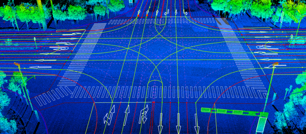
Using lidars to build centimeter-accurate HD maps is no small feat. You can use a lidar to create a centimeter- or inch-sized map of an entire city or to help you localize your AVs in the wild. These maps are typically vertically integrated with your AV software stack. The most advanced HD mapping technology combines lidars and cameras, to create highly accurate maps of roads, streets, as well as some infrastructures around the roads, such as light poles, vegetations, road marks, buildings, powerlines, and traffic signs etc.
A typical approach to creating the lidar HD map of an entire city involves assembling successive lidar scans into a large point cloud, then aligning them to produce a stacked map. While the process is not time-consuming anymore, thanks to LiDAR360 MLS with whole set of AI algorithm that can automate most of the post-process the LiDAR point cloud into vector objects. The end result can be a highly accurate map of an entire city. This can be used to help you with things like in-vehicle localization or augmented reality applications on mobile devices, as well as for the entire city planning or construction.
Our Solution for HD LiDAR Mapping
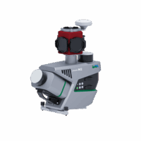
Hardware Equipment for HD LiDAR Mapping - LiBackpack and LiGrip
When the HD mapping project is small, for example only for few blocks , the handhelp and backpack LiDAR laser scanning system is sufficient. LiBackpack DGC50 and LiGrip are developed by GVI, and they are easy to operate, equiped with GNSS receiver that allows them to generate georeferenced 3D point cloud. Learn more about LiBackpack and LiGrip
Mobile Laser Scanners for HD LiDAR Mapping
When it comes to large-scale LiDAR laser scanning for HD map creation, mobile LiDAR scanner is better option, because they can operate at higher speed to improve the efficiency and save the labour at the same time create high density 3D point cloud.
HD LiDAR Mapping Point Cloud Data Analysis - LiDAR360 MLS
LiDAR360 MLS is a terrestrial mobile LiDAR laser scanning(MLS) point cloud feature extraction and analysis software independently developed by GreenValley International, which supports the processing and analysis of LiDAR point cloud and image data obtained by mainstream vehicle-mounted, backpack, or handled mobile mapping systems on the market.
Based on the leading artificial intelligence algorithm, the software performs massive point cloud data editing, 3D feature extraction and analysis, 3D vectorization of road elements, etc. It has the features of rich function, convenient operation, intelligent and efficient, friendly interaction, forming a complete processing chain of MLS point cloud data processing, high definition map and road asset survey.
The result data exported by the software can be directly imported into GIS, CAD, and simulation platforms, which can be widely used in high definition map production, facade survey, road asset survey and maintenance, etc. LiDAR360MLS accelerates information extraction with intelligence and depicts the real world with digitalization.
Video Demo
Key Features
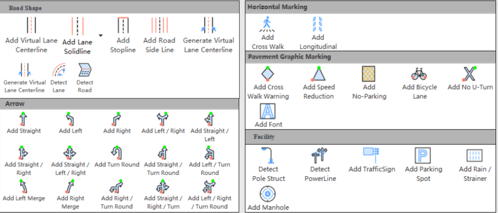
Automated Map Element Extraction
• Automatic extraction of road elements and road facilities based on AI from LiDAR HD mapping point cloud data, which greatly improves efficiency and can quickly expand categories.
• Customizable road element symbol library, the drawing effect is 100% fit.
• Support the drawing of special symbols such as characters and letters in various language, and enrich the achievement database.
• Interactive semi-automatic multi-element detection, improvement of mapping efficiency.
• Rich road element templates, one-click drag and drop.
• Support linear facility template customization to achieve batch extraction of line elements.
• Support individual segmentation and parameter extraction of road facilities such as trees and poles.
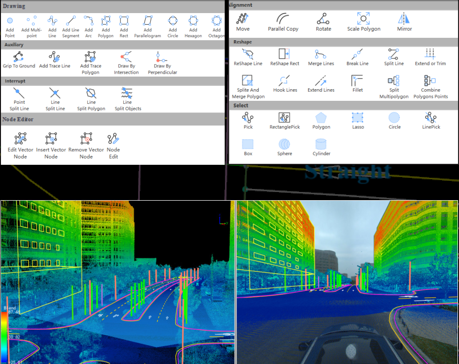
Rich Editor Tools
• Rich vector editing tools for automatically generated HD map from LiDAR point cloud, convenient operation, improve the accuracy and reliability of vectors.
• Support shortcut keys customization to improve the operability of production staff
• Support mapping in multi-view (3D, 2D, section).
• Support precise editing of different snap modes.
• Support attribute table template configuration.
• Built-in national standard road asset symbol library and general symbol library.
• Support point cloud, feature, vertex/edge multi-level data to add annotation.
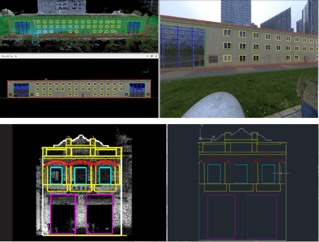
Facade Survey
• Seamlessly import LiGrip/LiBackpack/LiMobile point cloud and image data without format conversion and coordinate system definition.
• Provide multi-mode baseline collection method, adapt to multiple types of facade structures, and accurately locate side facade information.
• Provide facade verticalization function to solve the problem of SLAM data ground inclination.
• Provide convenient facade element drawing tools such as construction lines and grouping arrays to speed up production efficiency.
• Using panoramic images to assist facade survey, making the drawing of elements more complete and accurate.
• Provide accurate length and area calculation functions, and support exporting tables in other formats.
• Support exporting DXF, orthophoto result data,etc.
Road Analysis
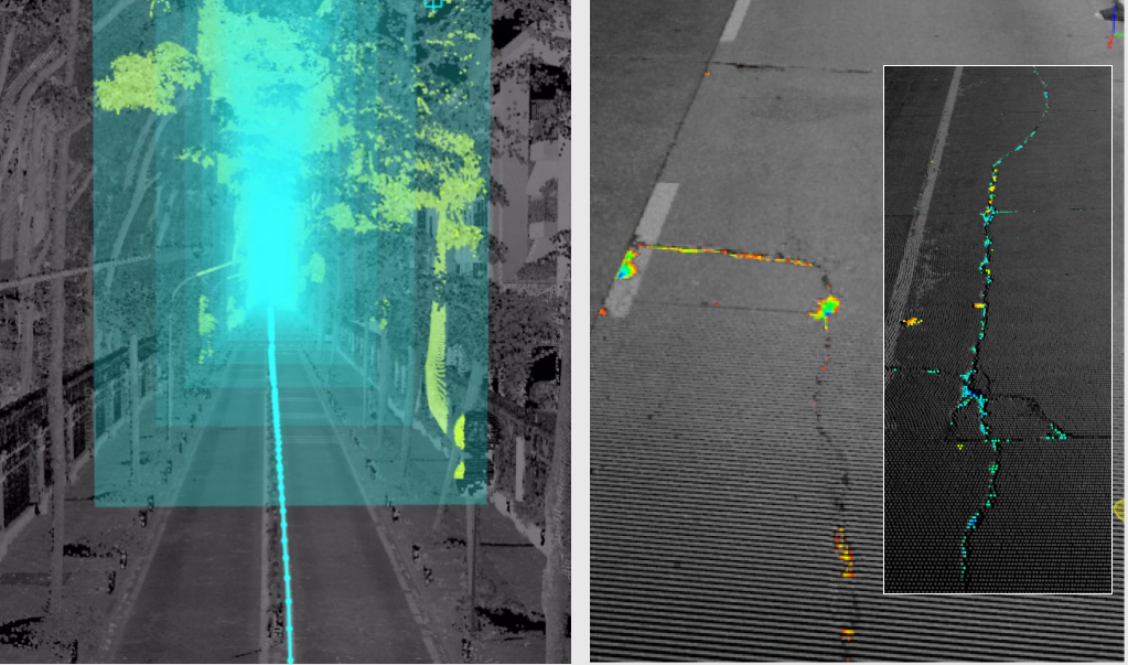
• Extract road surface damage information based on high-precision MLS point cloud data to assist road maintenance inspection.
• Support 3D space analysis methods such as clearance analysis and viewshed analysis.
• Support road section analysis, compare and analyze multi-phase data and generate standard comparison reports.
• Support the calculation of various road section parameters to assist in the analysis of road construction and other operations.