Riegl VUX / MiniVUX LiDAR Scanner - Integrated by Greenvalley International
GreenValley International has integrated few turn-key system for survey grade aerial LiDAR scanning system compatible with drone and helicopter platforms based on Riegle VUX & MiniVUX LiDAR Scanners. They are with high precision that generate survey grade data and easy to operate.
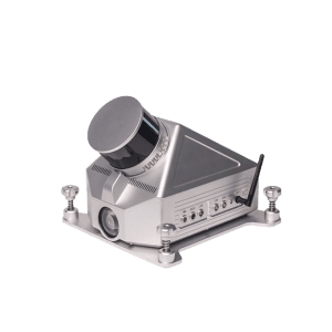
LiAir 250 Pro - LiDAR 3D Mapping System with Riegl LiDAR Sensor
Compatible with DJI M300 RTK, & M600
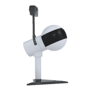
Laser Sensor: Riegl MiniVUX-3 UAV Range Accuracy: ± 1.5cm Detection Range: 330 m @ 80% reflectance System Accuracy: ± 3 cm @ AGL 80m Target echoes per laser shot: 5 Weight: 1.9 kg (Excl. Camera) 2.1 kg (Incl. Camera)
Overview
LiAir 250 Pro is GreenValley International’s flagship aerial land surveying LiDAR system designed to meet survey-grade project requirements. It is a power 3D mapping system equipped with a highly precise navigation system, and can generate point cloud data with an absolute vertical accuracy of 3 cm. Together with its capability of a 250 m range measurement and recording up to 5 returns per pulse, LiAir 250 is an ideal choice for applications like topographical survey beneath the forest canopy, extracting forest structure parameters from individual tree level to forest stand level, inspecting power line corridor, managing and inspecting asset, and so on. Moreover, LiAIr 250 also provides an option to be equipped with a high-definition digital camera, which can be used to generate photogrammetry products as well as true color 3D point clouds
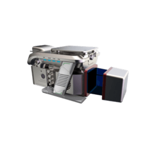
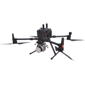
Laser Sensor: Riegl VUX-1 LR Max. Measurement Rate: 750,000 pts / sec Scan Rate: 10 Hz -200 Hz Field of View: 330° Scan Range: 1350 m @ Reflectance ≥ 60% Flight Height: 200 m System Accuracy: Horizontal Accuracy < 10 cm Horizontal Accuracy < 10 cm POS System Performance: Attitude: 0.005° (1σ) Azimuth: 0.009° (1σ) Weight: 17 kg Dimensions (Main Unit): 505 * 492 * 319 mm Power Consumption: 210 W Camera: Canon 5DSR Acquisition Software: LiAcquire-VUX Post-Processing Software (Optional): LiDAR360 & LiPowerline
Overview
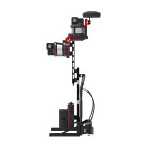
LiEagle is an aerial survey LiDAR scanner for surveying and it is designed for large area and long-range 3D data collection projects. The system is designed to be mounted to a helicopter platform and features a Riegl VUX-1LR laser scanner coupled with a best-in-class inertial measurement unit (IMU) for increased point cloud accuracy and precision. The LiEagle is well-suited for projects aiming to map terrain features beneath forest canopies and extract structural parameters from forest LiDAR data. The centimeter-level accuracy of this measurement device will meet the rigorous accuracy demands of civil engineering and critical infrastructure maintenance professionals. And an optional high-definition (50 megapixels) digital camera module can be used to generate photogrammetry products as well as true color 3D point clouds during each LiDAR survey.
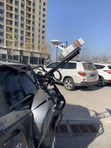
LiHawk - 3D LiDAR for Drone with Riegl VUX-1 LR LiDAR Sensor
Compatible with Multi-rotor & Fixed-wing Drone
Laser Sensor: Riegl VUX-1 LR Max. Measurement Rate: 750,000 pts / sec Scan Rate: 10 Hz -200 Hz Field of View: 330° Scan Range: 1350 m @ Reflectance ≥ 60% System Accuracy: Horizontal Accuracy < 10 cm, Vertical Accuracy < 10 cm Flight Height: 200 m POS System Performance: Attitude: 0.005° (1σ) Azimuth: 0.009° (1σ) Weight Incl.Camera: 4.35 kg Dimensions (Main Unit): 297 * 180 * 147 mm Flight Time: More than one hour Camera: SONY A7RII (24 mm prime lens) Post-Processing Software (Optional): LiDAR360 & LiPowerline
LiHawk is an aerial land LiDAR surveying system designed for large area and long-range 3D data collection projects. The system is designed to be mounted to a fixed-wing airplane platform or multi-rotor UAV and features a Riegl VUX-1LR laser scanner coupled with a best-in class inertial measurement unit (IMU) for increased point cloud accuracy and precision. LiHawk is wellsuited for projects aiming to map terrain features beneath forest canopies and extract structural parameters from forest LiDAR data. The centimeter-level accuracy of this measurement device will meet the rigorous accuracy demands of civil engineering and critical infrastructure maintenance professionals. And the high-definition digital camera module can be used to generate photogrammetry products as well as true color 3D point clouds during each LiDAR survey.