
Application of lidar technology in building facade vectorization
The 3D laser scanning technology uses the principle of laser ranging, and can quickly reconstruct the 3D model of the measured object and the lines, surfaces, and volumes by recording the 3D coordinates, reflectivity and texture of a large number of dense points on the surface of the measured object. and other graphic data. Since the 3D laser scanning system can obtain a large number of data points of the target object intensively, compared with the traditional single-point measurement, the 3D laser scanning technology is also known as a revolutionary technology that has evolved from single-point measurement to surface measurement. This technology is applied In building facade measurement, it can effectively improve the scientificity and accuracy of planning acceptance, implement planning intention, rational use of land, and real records of project construction, and the building facade measurement and survey results are also used by urban planning departments and supervision departments. Provide important law enforcement basis.
Check out our range of LiDAR products
LiDAR Scanner suitable for Building facade survey - liGrip
Greenvalley International have developed a few products that are suitable for LiDAR building facade survey applications. They adopt a simple style design, with a compact body, light hand-held, convenient operation and flexible installation; with a variety of sensors, it can quickly capture a wide range of scene data; it supports multi-platform and multi-mode operations, and is realized by combining lidar and SLAM algorithms. Indoor multi-scene integrated measurement.
The LiGrip handheld 3D laser scanning system can automatically, continuously and quickly acquire dense point cloud data on the surface of the target, which greatly improves the measurement efficiency.
The route is flexible, and the scanning route can be planned according to the building distribution and terrain trend, which mainly meets the accuracy and completeness requirements of external walls, windows, and detailed scanning.
The self-developed SLAM algorithm has high precision and good stability. For the collection of long strip-shaped streets, it can be scanned in sections every 200 meters to 300 meters, which helps to control the overall scanning accuracy and prevent the cumulative error of the strip scanning distance from being too long. .
LiDAR Building Facade survey work flow
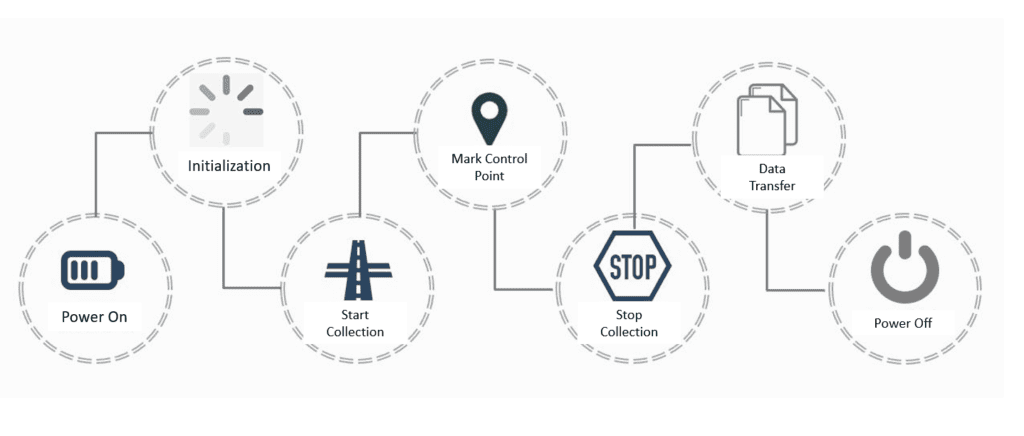
Site Data Collection Workflow
Data Processing Workflow for LiDAR Building Facade Survey
Point Cloud Data Reconstruction
Data Transfer from LiGrip to Workstation
Accuracy Verification - With RTK
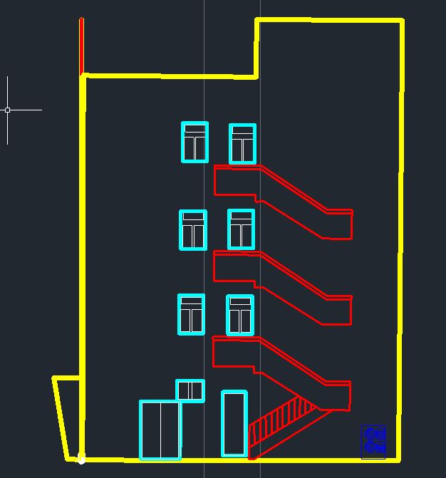
Generate the building facade vector drawing
Advantages of the Solution
1. Strong applicability: work all day, the measurement is not affected by light, and the work cycle can be flexibly formulated.
2. Non-contact measurement: stay away from dangerous areas to fully ensure the safety of equipment and operators.
3. No need to aim: LiGrip handheld laser scanner is separated from the aimer, objective lens and eyepiece necessary for instruments such as total station and theodolite, and automated measurement improves the efficiency of field operations.
4. No sketch connection required: The field data is more comprehensive, and there is no need to draw sketches, and comprehensive selections are made in the internal industry to complete the drawing task, and there is no need to go to the scene.
5. No perspective projection deformation: The photo shooting in photogrammetry technology is perspective projection, resulting in obvious deformation, while the laser scanner directly obtains the distance and angle like a total station, so there is no projection deformation at its point.
6. Joint CAD mapping: can directly draw points and lines based on the point cloud and send them to the CAD toolbar, including drawing 2D and 3D points, lines to CAD, setting and sending coordinates, etc. This tool can transfer the collected 2D polyline objects to AutoCAD software, which is convenient for surveying personnel to quickly collect 2D linear elements.