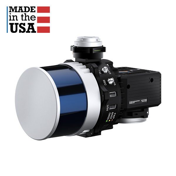
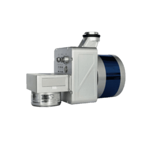
RESEPI-HESAI XT32 – From Inertial Labs, Manufactured In USA
Request For Quote
The RESEPI featuring HESAI’s XT-32 was strategically designed for multiple application bases. This solution is ideally suited for cost effective surveying work in applications involving open-pit mining, construction site monitoring, utility infrastructure management, and general volumetrics. The 360-degree FOV laser also makes this system well suited for various platforms and operation modes, including mobile vehicles, DJI supported drones (DJI M300, M600 Pro), custom drones, handheld platforms, vehicles, the Freefly Alta-X, and many more.
Introduction of RESEPI™ Hesai XT-32 LiDAR Scanner
About Inertial Labs
Inertial Labs is at the forefront of developing and manufacturing position and orientation technologies for the commercial sector, government, defense, and aerospace. Inertial Labs’ product catalog includes Inertial Measurement Units (IMU), Inertial Navigation Systems (INS), Motion Reference Units (MRU), and Wave Sensors (WS) along with RESEPI, our LiDAR scanning and mapping package. We supply solutions for land, sea, and air to exacting customers from some of the largest organizations in the world.
RESEPI Overview
RESEPI™ (Remote Sensing Payload Instrument) is a sensor-fusion platform designed for accuracy-focused remote sensing applications. RESEPI utilizes a high-performance Inertial Labs INS (GPS-Aided Inertial Navigation System) with a tactical-grade IMU and a high-accuracy single or dual-antenna GNSS receiver, integrated with a Linux-based processing core and data-logging software. The platform also provides a WiFi interface, optional imaging module, and external cellular modem for RTCM corrections. RESEPI can be operated by a single hardware button or from a wirelessly connected device via a simple web interface.
RESEPI WITH HESAI XT-32
Compact and light-weight, the RESEPI featuring HESAI’s XT-32 LiDAR scanner is an all-around very attractive system, offering the benefits of best-in-class data accuracy, good detection range, high point density, and versatility.
Key System Features of RESEPI™ Hesai XT-32 LiDAR Scanner
- System Vertical Accuracy: 2 – 3 cm(1)
- Precision: 2 – 4 cm(2)
- Precision: (1σ Noise Removal) 1.5 – 2.5 cm (3)
- Recommended AGL: Up to 100 m
- Weight: 1.7 kg (with camera), 1.3 kg (without camera)
- Dimensions: 20.8 x 17 x 14.2 (cm)
- Max Flight Time (DJI M300): 33 minutes
- External Storage: 256 GB USB Included
- System Computer: Quad Core, 1GB RAM,8GB eMMC
- Operational Voltage Range: 9-45V
- Power Consumption: 17W
RESEPI™
Hesai XT-32 Specs
LiDAR
Laser Range Capabilities
80m @ 10% ref. (c9-24);
50m @ 10% ref. (c1-8, 25-32);
0.05 to 120m
Range Accuracy
FOV (Horizontal)
FOV (Vertical)
Scan Angle (Vertical)
Laser Beam Divergence
0.04° (H), 0.098º(V)(5)
Number of Laser
Number of Returns
Pulse Rate
1280k/s (dual return)
Laser Safety
IMU
Grade IMU-P
GNSS
Constellations
QZSS, NavIC (IRNSS), SBAS, L-Band(7)
Frequencies
Operation Modes
Output Rates
Up to 2,000Hz (IMU)
Pitch/Roll Accuracy
0.006° (PPK)(9)
Heading Accuracy
0.03° (PPK)(10)
Velocity Accuracy
Position Accuracy
0.5cm (PPK)
Camera
Model
Lens
Max Trigger Rate
External Camera Support
Yes(6)
Software
Field Checks
Pre-Processing
Post-Processing
Notes:
(1)(2)Single Pass, 50m AGL, 5m/s, Nadir, Values Based on Inertial Labs Test Conditions.
(3)Single Pass, 50m AGL, 5m/s, Nadir, Single Noise Removal, Values Based on Inertial Labs Test Conditions.
(4)Dependent upon scanning pattern used
(5)Varies by measurement range
(6)For select models
(7)(8)Maximum available; dependent on receiver configuration
(9)Dynamic accuracy is dependent on type of motion
(10)Dynamic accuracy is dependent on type of motion; RTK with a 1-meter baseline
FAQ About RESEPI™ Hesai XT-32 LiDAR Scanner
The FAQ about RESEPI Payloads is coming soon.
Data Processing Software For RESEPI Payloads
Pre-processing
To get the .las format high quality point cloud out of the RESEPI LiDAR payloads for drone, vehicle mounted as wellas SLAM applicaiton.
-
LiDAR Point Cloud Processing Software
PCMaster Pro – Pre-processing Software For RESEPI LiDAR Payload – 1 Year Subscription
US$2,500.00 – US$3,500.00 Excl. GST/VAT View productsRated 0 out of 5
Post-processing
Once the .las file is generated from PCMaster Pro, then you can use following point cloud processing software to genarate the final deliverables required.
-
LiDAR Point Cloud Processing Software
LiDAR360 MLS Mobile/Handheld LiDAR Point Cloud Processing Software – 1 Year Subscription
US$4,890.00 Excl. GST/VAT Add to cartRated 0 out of 5 -
LiDAR Point Cloud Processing Software
LiPowerline – Powerline Point Cloud Data Analyzing Software – 1 Year Subscription
US$3,150.00 Excl. GST/VAT Add to cartRated 0 out of 5 -
LiDAR Point Cloud Processing Software
LiDAR360 Aerial LiDAR Point Cloud Processing & Analyzing Software – 1 Year Subscription
US$4,300.00 Excl. GST/VAT Add to cartRated 0 out of 5
Related products
-
drone lidar with premium INS
RESEPI-TELEDYNE CL-360HD – From Inertial Labs, Manufactured In USA
Request For Quote Read MoreRated 0 out of 5 -
drone lidar with premium INS
RESEPI-HESAI XT32M2X – From Inertial Labs, Manufactured In USA
Request For Quote Read MoreRated 0 out of 5 -
Entry Level drone LiDAR
LiAir X3C-H Drone LiDAR Scanner – 32 Channel LiDAR Sensors – 300M Dection Range
Request For Quote Read MoreRated 0 out of 5 -
Entry Level drone LiDAR
LiAir X3 + LiGeo Software and Camera – Global Shipping – Free Software Included
Request For Quote Read MoreRated 0 out of 5

