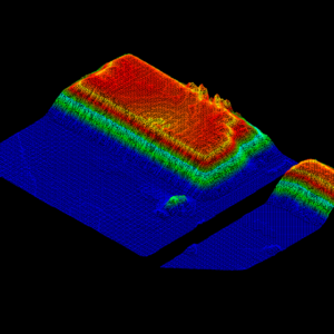
LiDAR Products
- Bankable wind LiDAR (Vertical Profiler) for Wind farm development measurement;
- 3D Scanning wind LiDAR for meteorological, wind shear & aircraft vortex measurement for airports;
- Wind turbine nacelle-mounted wind LiDARs for power performance test, yaw misalignment correction, and energy yield improvement etc.
- UAV & helicopter mounted LiDAR scanning payloads, from entry level to premium accuracy equipment;
- Terrestrial LiDAR scanning equipment, such as handheld, backpack, and vehicle mounted LiDAR equipment
- LiDAR point cloud data pre & post processing software;
- Latent Jacking Handling AGV
- Indoor Automated Forklift
- Outdoor Automated Forklift
- Automatic forklift control system for retrofit existing fleet
LiDAR Survey & Wind Measurement Services
LiDAR for Building Information Modelling BIM
LiDAR Scanning For Building Information Modelling (BIM) Services | Efficient & Accurate | End to End Solution BIM has the characteristics of visualization, coordination, simulation,
Turn-key Wind Monitoring LiDAR System
Turn-key Wind Measurement LiDAR Solution for Australian & New Zealand Wind Projects Patent Pending Turn-key Wind LiDAR System, Patent Application Number: AU 2022901693 LiDAR Solutions
Wind turbine blade inspection with drone
Wind Turbine Blade Inspection with Drone powered by Cutting Edge AI Technology The smartest and most efficient way to inspect the wind turble blades with
Solar Farm Inspection and Cleaning
Solar Farm Inspection with Drone powered by Cutting Edge AI Technology Coming Soon………… Request Information and Quote
Forestry Survey – LiDAR Survey System and Software
LiDAR Forestry Survey – GVI LiDAR Scanning System and Processing Software in Australia In the process of forestry surveying, Lidar is used to map the
LiDAR for Construction
LiDAR For Construction Solutions & Services | Efficient & Accurate | End to End Solution LiDAR Scanning for Construction A LiDAR (light detection & ranging)
LiDAR Road Survey & Dimensional Analysis for ODL Transport
LiDAR Road Survey for Over-dimensional Load Transport Using LiDAR to perform a road survey is very useful. It can provide accurate results with little time
LiDAR Powerline Inspection
Powerline, Transmission Line & Substation Inspection with Drone and Mobile LiDAR Scanners Powerline, transmission line and substation inspection with Drone and Terrestrial LiDAR is an
HD LiDAR Mapping Urban Town
HD LiDAR mapping with Mobile & Aerial LiDAR Laser Scanning | Urban & Town Area Using a 3D LIDAR Laser Scanning for HD LiDAR mapping
Customers reviews
What people say?
I have had the privilege of collaborating closely with Lidar Solutions Australia for a multitude of overhead line design projects within our portfolio. Having executed numerous expansive ventures reliant on the survey data provided by Lidar Solutions, I can unequivocally affirm that their service is exemplary in terms of quality and cost-effectiveness. In particular, when it comes to ASP/3 projects, Lidar Solutions has consistently delivered exceptionally accurate results with commendable punctuality.
LiDAR Solutions' GreenValley LiDAR mapping products have truly set the gold standard in the industry, combining unparalleled performance with a refreshingly affordable cost structure. It's worth noting that our experience with Wallace has been nothing short of exceptional, as he consistently goes above and beyond in delivering outstanding product service and unwavering technical support, ensuring that our needs are not just met, but exceeded in every regard.
Case Studies
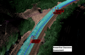
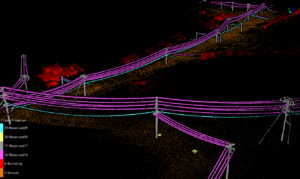
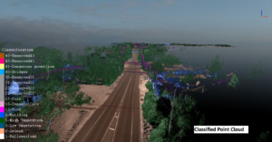
How did mobile LiDAR scanning speed up and improve the powerline 3D model creation and encrochment assessment?
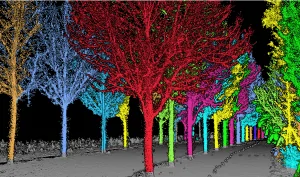
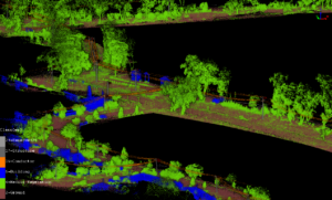
What is mobile LiDAR Scanning system? A mobile lidar scanning system is a technique that captures highly comprehensive and precise 3D data of the surroundings
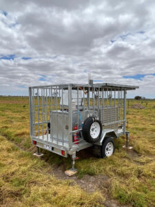
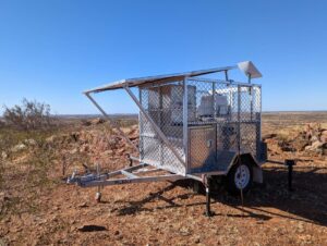
Turn-key Molas B300 Wind LiDAR System Passed The Performance Test in Victoria, Australia
The performance test for Molas B300 wind LiDAR system has been done between end of June to End of September near Geelong, Victoria, Australia together
Application of lidar technology in building facade vectorization
The 3D laser scanning technology uses the principle of laser ranging, and can quickly reconstruct the 3D model of the measured object and the lines,
Creating A Floor Plan With LiGrip Laser Floor Plan Scanner
Creation A Floor Plan with LiGrip-Handheld Lidar Laser Scanner In municipal planning, house demolition, interior decoration and other projects, the floor plan information of the
GPS RTK Receiver for Construction Applications
If you are considering using a GPS RTK Receiver in your construction project, there are several benefits to consider. First of all, GPS technology offers
Smart Mine LiDAR 3D Scanning Solution
With the advancement of modern surveying and mapping technology, the amount of data measured in mines is increasing, such as 3D mine mapping for open