
Creating A Floor Plan With LiGrip Laser Floor Plan Scanner
Creation A Floor Plan with LiGrip-Handheld Laser Floor Plan Scanner
In municipal planning, house demolition, interior decoration and other projects, the floor plan information of the building is very important. Efficient, accurate and fast creation the floor plan of the building can help shorten the project engineering, reduce costs and increase efficiency. Today, we will focus on introducing the indoor floor plan measurement solution based on LiGrip laser floor plan scanner products.
First, the needs of Creating a floor plan
1. Real estate floor plan creation
When the building is completed, or the real estate is changed later, the real estate needs to be surveyed and mapped. The traditional surveying and mapping methods are the coordinate analysis method, the field measurement method and the graphic method. But the traditional methods face the following problems:
(1) The number of real estate surveying, mapping and surveying projects is large and concentrated, but the delivery time is short, often within 10-20 days, resulting in the inability to undertake more projects;
(2) The surveying and mapping unit has purchased a lot of equipment, but one type of equipment can only output one kind of result, which requires repeated measurement and low reusability;
(3) There are differences in the results measured by different personnel. When the field measurement is wrong, the internal personnel cannot effectively judge the error;
(4) The 3D construction of the real scene is imminent, and the traditional equipment can only meet the collection of 2D information, but cannot meet the needs of customers for 3D information;
(5) The existing measurement tools have a large workload and high labor costs when collecting in the field;
(6) The requirements for operators are high, and the training period of a qualified real estate surveying and mapping personnel is often long.
Therefore, real estate surveying and mapping needs a measurement method with high accuracy, fast speed, low learning difficulty, and output of various data results.
2. Engineering quantity calculation
In some building decoration and renovation projects, such as residential buildings, schools, and projects, it is necessary to count the construction volume of the construction party as a basis for subsequent settlement of construction payments. Traditional surveying and mapping methods face the following problems:
(1) Some reconstructed objects lack drawings, such as old communities and schools, so it is necessary to conduct on-the-spot measurements and count engineering quantities;
(2) The engineering quantity is three-dimensional, such as: interior and exterior wall plastering, interior floor tiles, and the wall area belong to different planes and are three-dimensional;
(3) The existing measuring tools have a large workload and high labor costs;
(4) Since the engineering volume is three-dimensional, the requirements for the operators of the industry are relatively high, and the training time is relatively long.
Therefore, the common points of the needs of the above two fields are summarized as follows:
(1) Cost reduction and efficiency increase: while the cost performance of products is improved, the workload of the field is reduced, and the work efficiency of floor plan drawing can be greatly improved;
(2) Advanced technology: in line with the development direction of the domestic surveying and mapping industry, with advanced nature;
(3) Reusability: Equipment operations can be carried out according to the needs of various scenarios, and the results can be output in a variety of ways, with strong reusability;
(4) Quick start: The equipment is easy to use and easy to operate.
2. Technical scheme of indoor Laser floor plan Mapping
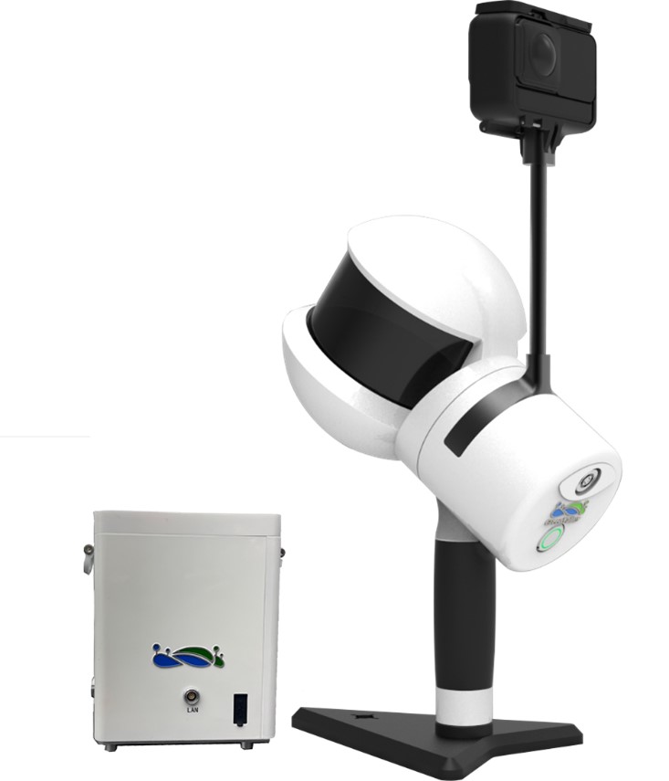
The high-precision characteristics of the LiGrip 3D floor plan scanner can provide accurate and stable data for floor plan measurement. Combined with the efficient and intelligent LiFuser-BP solution software, it can effectively improve the measurement efficiency and reduce the time for office processing cost. The integrated measurement of indoor and outdoor scenes can be achieved by using lidar and SLAM algorithms, which are widely used in forestry, underground space, floor plan mapping, mine roads, street facades, heap volume and other fields.
Overall program process:
Data Collection with LiGrip
LiFuser-BP SLAM data solution and preprocessing
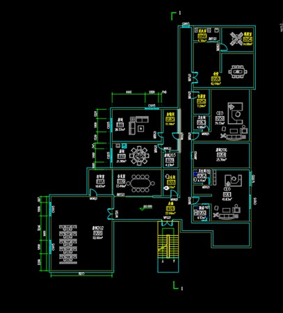
LiStreet software floor plan drawing
3. Advantages of LiGrip Laser Floor Plan scanner
The advantages of the LiGrip-based elevation measurement solution compared to the traditional floor plan creation solution with a rangefinder are as follows:
(1) The field efficiency of floor plan creation is greatly improved
The measurement method of the traditional distance meter is unilateral distance measurement. For example, if the house is a polygonal row or a special-shaped house, the measurement efficiency is low. Generally speaking, a group of 2 people can measure 500-1000 square meters a day;
The equipment of SLAM technology can obtain data as long as the measured target is within the measurement range. The operation efficiency of LiGrip can measure at least tens of thousands of square meters a day, which is 10 times more than that of traditional rangefinders.
(2) The data is real and effective, and there is no human observation error
The rangefinder obtains data by measuring the straight-line distance between two points. If the laser line of sight of the rangefinder is not parallel to the measured object, it will cause a ranging error. Usually, it is necessary to measure multiple edges for accumulation, so that the error will gradually accumulate;
The SLAM technology does not rely on human observation. As long as the walking route is reasonable, the data is real and effective.
(3) High point density, full coverage measurement
The rangefinder needs to obtain the data of the object in advance, such as a door and window, needs to obtain the length, width and height from the ground, etc., and requires the proficiency of the operator;
LiGrip acquires the measured target in all directions (320,000 points/second). The LiGrip therefore prevents field personnel from missing certain objects and measurements during acquisition.
(4) No need to draw sketches on site
During routine plane data collection, operators are required to draw plane sketches and plot dimensions on the drawings, and personnel are required to have drawing and spatial understanding skills;
On the other hand, LiGrip does not need to draw sketches on site, and can record 3D point clouds and images on site.
(5) No need for on-site photo recording
During traditional plane measurement, it is necessary to take pictures of objects on the spot, so that it can be used as a reference, status record, and area calculation basis when drawing in the office;
LiGrip not only obtains point clouds, but also obtains panoramic images, which is convenient for viewing the point cloud and panoramic image information of the measured target.
(6) Simple interior drawing
Compared with the simple point, line and surface method of sketch, the three-dimensional point cloud method allows users to intuitively feel the object, and the combination of panorama and point cloud makes the drawing vivid and three-dimensional.
4. Achievement display of creating a floor plan with liDAR Laser scanning
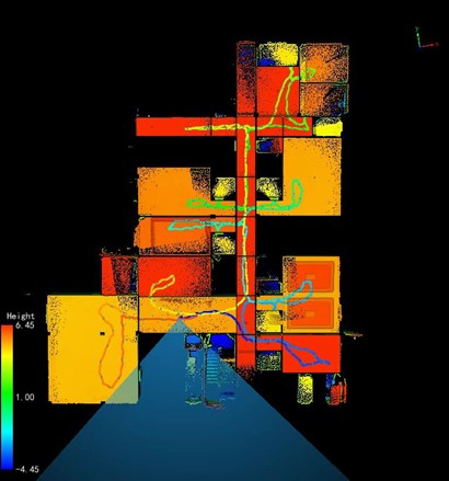
1. Original point cloud
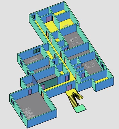
2. Floor plan display
3. 3D model picture display
Laser scan surveys gather millions of accurate points that create a 3D image which can be processed and used in nearly all CAD and 3D Modelling systems. Scanning is high accuracy, high speed and is the best and safest way of taking measurements which can be used to design and construct.laser scanning in construction industry