
Exploring the World Through Lidar Scan: A Comprehensive Guide
Table of Contents
Introduction to Lidar Technology
Light Detection and Ranging, or Lidar, is a revolutionary technology that is changing how we perceive the environment. This method makes use of laser light to map the environment in high detail and measure distances. Lidar scans provide unmatched precision and detail, helping everything from driverless vehicles to transforming archaeological discoveries.
Understanding the Basics of Lidar
Fundamentally, a lidar scan entails directing laser beams at a surface or object and timing how long it takes for the light to return. The target region may be precisely represented in three dimensions thanks to this time-of-flight technique.
Evolution of LiDAR Systems
LiDAR was first developed in the 1960s, not long after the laser was created. LiDAR was first employed in meteorology to investigate clouds and air pollution. During the Apollo lunar landing missions, the technology was first acknowledged for its promise in remote sensing and topographical mapping, when it was utilized to map the lunar surface.
Advances in technology during the 1980s and 1990s resulted in notable enhancements to LiDAR systems. The precision of LiDAR was improved by the inclusion of Global Positioning System (GPS) technology, enabling accurate location mapping. Large-scale topographical mapping and surveying have become more and more common using airborne LiDAR, which required installing the equipment on an aircraft. During this time, component miniaturization also occurred, leading to more compact and effective LiDAR systems.
Over the past ten years, LiDAR has gotten smaller, cheaper, and more accurate. Since the introduction of driverless vehicles, LiDAR technology has become increasingly important, attracting substantial funding and research efforts. In addition to being more compact, contemporary LiDAR systems also use less energy and may provide data with a higher resolution.
Future developments of LiDAR sensors are expected to yield even more advanced models with increased speed, resolution, and range. An increasingly popular topic is integration with machine learning and artificial intelligence, which improves data processing and analytical capabilities. To enable the technology for a wider range of applications, there is also an emphasis on creating affordable LiDAR systems.
Understanding LiDAR Scans
How LiDAR Scans Work
Light detection and ranging, or LiDAR scanning, is a type of remote sensing that measures distances to Earth by using light in the form of a pulsed laser. This is a thorough description of how LiDAR scanning operates:
Emission of Laser Pulses:
Laser pulses are directed at the target region by the LiDAR system. These lasers can operate in the visible, ultraviolet, or infrared light spectrums.
The target region is covered in a methodical way by the fast-emitting pulses.
Measurement of Travel Time:
The laser pulse returns to the LiDAR sensor after striking the target surface.
Each pulse’s return time is measured by the LiDAR system. Since light travels at a constant speed, the round-trip duration of each laser pulse may be used to determine the distance between the target and the LiDAR sensor.
Generation of Point Clouds:
Using the distance information gathered from the laser pulses that return, “point clouds,” or big collections of data points that depict the area scanned, are created.
A three-dimensional representation of the target area is produced by assigning a unique set of coordinates (latitude, longitude, and height) to each point in the cloud.
Processing and Interpretation:
The point cloud data is processed in raw form to eliminate noise and extraneous information.
The point cloud is interpreted using sophisticated software and algorithms, which convert data into formats that may be used, like 3D models or topographic maps.
Integration with GPS and IMU:
The GPS (Global Positioning System) and IMU (Inertial Measurement Unit) are included into the majority of LiDAR systems.
Precise position data is supplied by the GPS, while the IMU monitors the LiDAR system’s orientation and movement—particularly crucial for airborne LiDAR.
Understanding the Doppler Effect in LiDAR
The components of LiDAR Scanning System
Several essential parts of a LiDAR (Light Detection and Ranging) scanning system cooperate to collect and process environmental data. These elements, each of which has a distinct purpose in the scanning process, are essential to the LiDAR system’s operation. The following are the principal parts of a LiDAR system:
Laser:
This is the main power source for the LiDAR system, shooting light pulses in the direction of the target region or object, usually in the infrared range. Depending on the application, the laser’s properties, such as wavelength and pulse rate, may change.Scanner and Optics:
The laser pulses are directed over the survey region by the scanning system. Moreover, it collects the light that is reflected back into the system.
The reflected light and laser beams are focused and directed by the optics, which includes mirrors and lenses.Photodetector and Receiver Electronics:
The sensor that finds the pulses of reflected light is called a photodetector.
The detected light is transformed into electrical impulses by the receiver electronics so that it can be measured and examined.Position and Navigation Systems:
The Global Positioning System, or GPS, is utilized to pinpoint the exact location of the LiDAR system; this is particularly important for aerial LiDAR systems.
GPS and Inertial Measurement Units (IMUs) are frequently used together. It guarantees precise laser data location by giving details about the LiDAR system’s orientation, tilt, and altitude.Data Storage and Processing Unit:
Systems that use onboard memory save captured data.
The raw data is processed into formats that may be used by processing devices, which are usually computers equipped with specialized software. This processing involves producing point clouds or other visual representations and converting the time-of-flight of laser pulses into distance measurements.Power Supply:
Batteries, an electrical connection, or an alternative power source may be used to power a LiDAR system, depending on its design and intended use, particularly for mobile or aerial systems.Mounting Platform:
The LiDAR system type determines the platform. In terrestrial systems, a tripod could be used. A satellite, drone, or airplane could serve as the platform for airborne systems.
When combined, these elements give the LiDAR system the ability to precisely record and display the physical features of the scanned area in three dimensions. LiDAR systems’ sophistication and capabilities are still developing, making it possible to collect data for a variety of applications that is increasingly exact and detailed.
In the context of LiDAR (Light Detection and Ranging), the term “Doppler effect” refers to the shift in wavelength or frequency of light reflected back to the sensor from a moving object. This phenomena is comparable to the better-known Doppler effect in sound, in which an object’s frequency varies in response to its motion relative to the observer.
The Doppler effect is employed in LiDAR systems to calculate an object’s or surface’s velocity.
How Lidar Scans Work
The Science Behind Lidar Scanning
LiDAR (Light Detection and Ranging) data is collected using a process that involves emitting light pulses and measuring the time it takes for them to return after hitting an object or surface. This technology is often used to create detailed three-dimensional information about the shape of the Earth and its surface characteristics.
Some LiDARs, like wind measurement LiDARs use Doppler Effect to measure the moving speed of the aersols in the air to measurement wind speed for renewable and atomospheric monitoring projects.
Components of a Lidar System
LiDAR (Light Detection and Ranging) data is collected using a process that involves emitting light pulses and measuring the time it takes for them to return after hitting an object or surface. This technology is often used to create detailed three-dimensional information about the shape of the Earth and its surface characteristics.
Some LiDARs, like wind measurement LiDARs use Doppler Effect to measure the moving speed of the aersols in the air to measurement wind speed for renewable and atomospheric monitoring projects.
Energy Sector
In the energy sector, LiDAR is used to assess the potential of wind and solar energy projects. It helps in the planning and design of wind farms and solar power plants by providing detailed information about the terrain and sunlight availability.
LiDAR can be used for the renewable projects for various purposes, such as:
Onshore wind resource measurement;
Offshore wind resource measurement;
Wind turbine nacelle mounted LiDAR for power performance test and control optimization;
LiDAR can also be applied for disaster management, archaeology, and environment monitoring.
Disaster Management
LiDAR can be used to assess the impact of natural disasters such as floods, earthquakes, and landslides. It helps in disaster planning and mitigation by providing accurate information about the affected areas.
Archaeology
LiDAR technology is used in archaeology to detect and map ancient structures and landscapes. It helps uncover hidden archaeological sites without the need for extensive excavations.
Environmental Monitoring
LiDAR is used to monitor environmental changes, such as deforestation, erosion, and changes in land cover. It provides valuable data for researchers studying climate change and its impacts on the environment.
Applications of Lidar Scans
Environmental Monitoring
The principle of ranging is currently mainly based on the time of flight (time of flight) method, which uses the time interval between the pulse signal emitted by the transmitter and the reflected pulse signal received by the receiver to calculate the distance to the target object. Please find the indication of Time of Flight principle for details.
Urban Planning and Development
The principle of ranging is currently mainly based on the time of flight (time of flight) method, which uses the time interval between the pulse signal emitted by the transmitter and the reflected pulse signal received by the receiver to calculate the distance to the target object. Please find the indication of Time of Flight principle for details.
Advances in Autonomous Vehicles
Lidar in Archeology and Heritage Conservation
Lidar Scan Accuracy and Precision
Factors Influencing Accuracy
LiDAR (Light Detection and Ranging) data is collected using a process that involves emitting light pulses and measuring the time it takes for them to return after hitting an object or surface. This technology is often used to create detailed three-dimensional information about the shape of the Earth and its surface characteristics.
Some LiDARs, like wind measurement LiDARs use Doppler Effect to measure the moving speed of the aersols in the air to measurement wind speed for renewable and atomospheric monitoring projects.
Comparing Lidar with Traditional Survey Methods
LiDAR (Light Detection and Ranging) data is collected using a process that involves emitting light pulses and measuring the time it takes for them to return after hitting an object or surface. This technology is often used to create detailed three-dimensional information about the shape of the Earth and its surface characteristics.
Some LiDARs, like wind measurement LiDARs use Doppler Effect to measure the moving speed of the aersols in the air to measurement wind speed for renewable and atomospheric monitoring projects.
Types of Lidar Systems
Airborne vs. Terrestrial Lidar
The principle of ranging is currently mainly based on the time of flight (time of flight) method, which uses the time interval between the pulse signal emitted by the transmitter and the reflected pulse signal received by the receiver to calculate the distance to the target object. Please find the indication of Time of Flight principle for details.
Bathymetric Lidar for Marine Environments
The principle of ranging is currently mainly based on the time of flight (time of flight) method, which uses the time interval between the pulse signal emitted by the transmitter and the reflected pulse signal received by the receiver to calculate the distance to the target object. Please find the indication of Time of Flight principle for details.
Challenges and Limitations of Lidar Scans
Environmental Constraints
LiDAR (Light Detection and Ranging) data is collected using a process that involves emitting light pulses and measuring the time it takes for them to return after hitting an object or surface. This technology is often used to create detailed three-dimensional information about the shape of the Earth and its surface characteristics.
Some LiDARs, like wind measurement LiDARs use Doppler Effect to measure the moving speed of the aersols in the air to measurement wind speed for renewable and atomospheric monitoring projects.
Technical Challenges and Limitations
LiDAR (Light Detection and Ranging) data is collected using a process that involves emitting light pulses and measuring the time it takes for them to return after hitting an object or surface. This technology is often used to create detailed three-dimensional information about the shape of the Earth and its surface characteristics.
Some LiDARs, like wind measurement LiDARs use Doppler Effect to measure the moving speed of the aersols in the air to measurement wind speed for renewable and atomospheric monitoring projects.
Future of Lidar Technology
Innovations on the Horizon
The principle of ranging is currently mainly based on the time of flight (time of flight) method, which uses the time interval between the pulse signal emitted by the transmitter and the reflected pulse signal received by the receiver to calculate the distance to the target object. Please find the indication of Time of Flight principle for details.
Integrating Lidar with Other Technologies
The principle of ranging is currently mainly based on the time of flight (time of flight) method, which uses the time interval between the pulse signal emitted by the transmitter and the reflected pulse signal received by the receiver to calculate the distance to the target object. Please find the indication of Time of Flight principle for details.
Lidar Scan
In-depth Analysis of Lidar Scan Process
LiDAR (Light Detection and Ranging) data is collected using a process that involves emitting light pulses and measuring the time it takes for them to return after hitting an object or surface. This technology is often used to create detailed three-dimensional information about the shape of the Earth and its surface characteristics.
Some LiDARs, like wind measurement LiDARs use Doppler Effect to measure the moving speed of the aersols in the air to measurement wind speed for renewable and atomospheric monitoring projects.
Converting Raw Data to Meaningful Information
LiDAR (Light Detection and Ranging) data is collected using a process that involves emitting light pulses and measuring the time it takes for them to return after hitting an object or surface. This technology is often used to create detailed three-dimensional information about the shape of the Earth and its surface characteristics.
Some LiDARs, like wind measurement LiDARs use Doppler Effect to measure the moving speed of the aersols in the air to measurement wind speed for renewable and atomospheric monitoring projects.
Software and Tools for Lidar Data Analysis
Lidar and the Environment
Lidar's Role in Environmental Conservation
The principle of ranging is currently mainly based on the time of flight (time of flight) method, which uses the time interval between the pulse signal emitted by the transmitter and the reflected pulse signal received by the receiver to calculate the distance to the target object. Please find the indication of Time of Flight principle for details.
Impact of Lidar on Wildlife and Natural Habitats
The principle of ranging is currently mainly based on the time of flight (time of flight) method, which uses the time interval between the pulse signal emitted by the transmitter and the reflected pulse signal received by the receiver to calculate the distance to the target object. Please find the indication of Time of Flight principle for details.
Economic Aspects of Lidar Technology
Cost Analysis of Lidar Systems
LiDAR (Light Detection and Ranging) data is collected using a process that involves emitting light pulses and measuring the time it takes for them to return after hitting an object or surface. This technology is often used to create detailed three-dimensional information about the shape of the Earth and its surface characteristics.
Some LiDARs, like wind measurement LiDARs use Doppler Effect to measure the moving speed of the aersols in the air to measurement wind speed for renewable and atomospheric monitoring projects.
Return on Investment for Lidar Technology
LiDAR (Light Detection and Ranging) data is collected using a process that involves emitting light pulses and measuring the time it takes for them to return after hitting an object or surface. This technology is often used to create detailed three-dimensional information about the shape of the Earth and its surface characteristics.
Some LiDARs, like wind measurement LiDARs use Doppler Effect to measure the moving speed of the aersols in the air to measurement wind speed for renewable and atomospheric monitoring projects.
Software and Tools for Lidar Data Analysis
Legal and Ethical Considerations in Lidar Use
Privacy Concerns with Lidar Scanning
The principle of ranging is currently mainly based on the time of flight (time of flight) method, which uses the time interval between the pulse signal emitted by the transmitter and the reflected pulse signal received by the receiver to calculate the distance to the target object. Please find the indication of Time of Flight principle for details.
Regulatory Framework for Lidar Technology
The principle of ranging is currently mainly based on the time of flight (time of flight) method, which uses the time interval between the pulse signal emitted by the transmitter and the reflected pulse signal received by the receiver to calculate the distance to the target object. Please find the indication of Time of Flight principle for details.
Lidar in Popular Culture
Lidar in Movies and Media
LiDAR (Light Detection and Ranging) data is collected using a process that involves emitting light pulses and measuring the time it takes for them to return after hitting an object or surface. This technology is often used to create detailed three-dimensional information about the shape of the Earth and its surface characteristics.
Some LiDARs, like wind measurement LiDARs use Doppler Effect to measure the moving speed of the aersols in the air to measurement wind speed for renewable and atomospheric monitoring projects.
Public Perception of Lidar Technology
LiDAR (Light Detection and Ranging) data is collected using a process that involves emitting light pulses and measuring the time it takes for them to return after hitting an object or surface. This technology is often used to create detailed three-dimensional information about the shape of the Earth and its surface characteristics.
Some LiDARs, like wind measurement LiDARs use Doppler Effect to measure the moving speed of the aersols in the air to measurement wind speed for renewable and atomospheric monitoring projects.
Software and Tools for Lidar Data Analysis
FAQs about LiDAR
How does lidar technology differ from traditional surveying methods?
LiDAR, which stands for Light Detection and Ranging, is a remote sensing technology that uses laser light to measure distances and create detailed 3D representations of objects and environments.
What are the environmental impacts of using lidar scans?
LiDAR works by emitting laser pulses and measuring the time it takes for the light to reflect off objects and return to the sensor. This data is used to calculate distances and create accurate 3D models.
Can lidar technology be used in urban planning and development?
LiDAR is used in various applications including autonomous vehicles, forestry, agriculture, archaeology, urban planning, environmental monitoring, and more.
How accurate and precise are lidar scans compared to other mapping technologies?
LiDAR is a crucial sensor in autonomous vehicles, helping them create detailed maps of their surroundings and detect obstacles in real-time for safe navigation.
How Accurate is LiDAR?
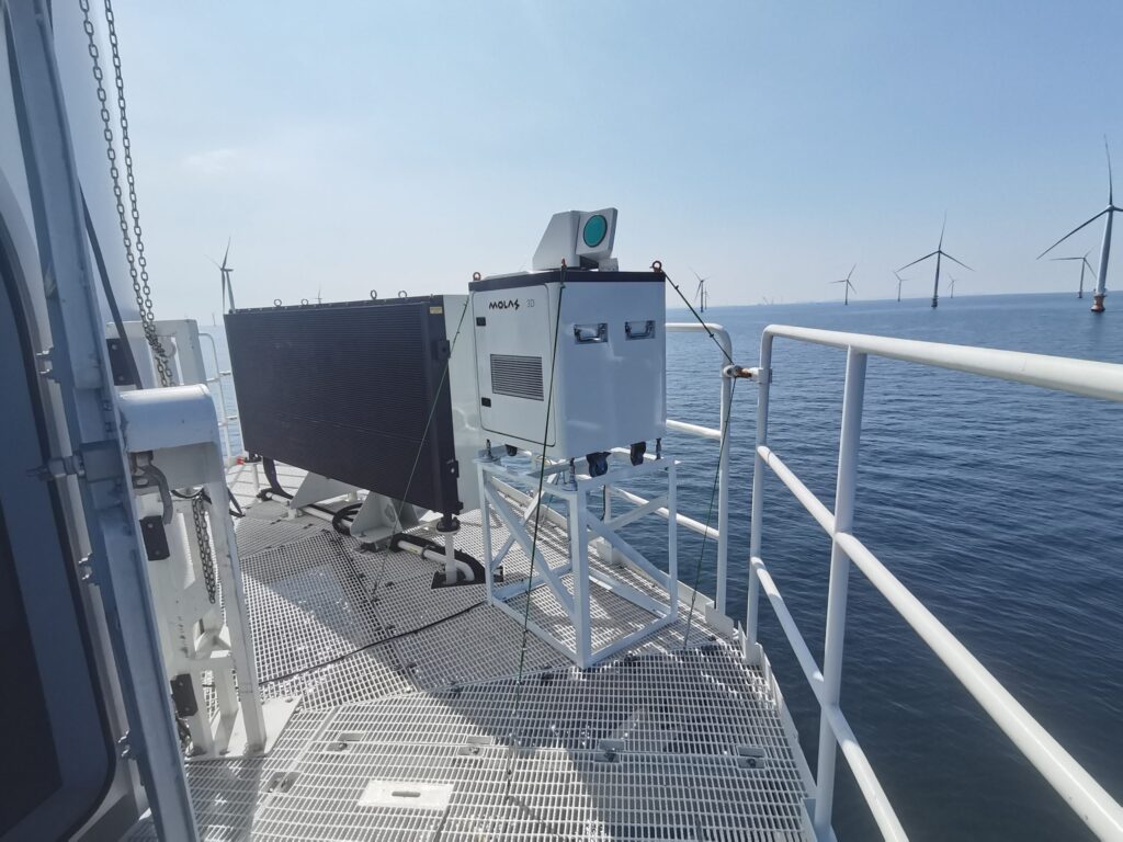
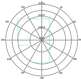
Survey LiDAR systems:
There are mainly two types of survey LiDAR systems: airborne LiDAR, which is mounted on aircraft for wide-area mapping, and terrestrial LiDAR, which is ground-based and captures detailed data of smaller areas.
Wind LiDAR systems:
Wind LiDAR uses doppler effect to measure the wind speed and direction, which can be applied for renewable, civil aviation and atomospheric monitoring. There are few types of them:
Can LiDAR See Through Vegetation or Buildings?
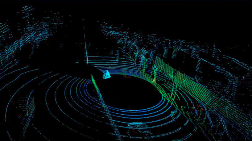
2D LiDAR only measures distances in a single plane, while 3D LiDAR measures distances in multiple directions, capturing a more comprehensive view of the environment. Here are the point cloud comparison between 2D & 3D LiDAR.
What's the Difference Between Aerial and Terrestrial LiDAR?
LiDAR can provide highly accurate distance measurements, often within a few centimeters. The accuracy depends on factors such as the type of LiDAR system, the quality of the equipment, and environmental conditions.
Most LiDARs use TOF (Time of Flight) measurement, the further the object is, the more accurate is the measurement, as it is more difficult to measure the time of the light travelling in the lower range.
Is LiDAR Data Affected by Weather?
The range of LiDAR can vary depending on the technology and equipment used. It can range from a few meters to several kilometers. Nowadays, most long range LiDARs use 1550nm wavelength light for detection.
What's The Difference Between LiDAR And RADAR?
LiDAR uses laser light, while RADAR uses radio waves. LiDAR typically provides higher resolution and accuracy in detecting objects and capturing details.
Learn more about detailed comparison between LiDAR and RADAR.