Find Us In Booth W60

LiDAR Road Survey for Over-dimensional Load Transport

Using LiDAR to perform a road survey is very useful. It can provide accurate results with little time and effort. The survey will deliver a digital 3D model of the road, which can be used for a variety of purposes. The LiDAR point cloud data can also be colorized which allows engineers to identify the road obstacles better and easier. This information can help with the planning of transport rountes and determine the dimension limitations of the loads to be transported.


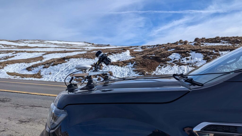
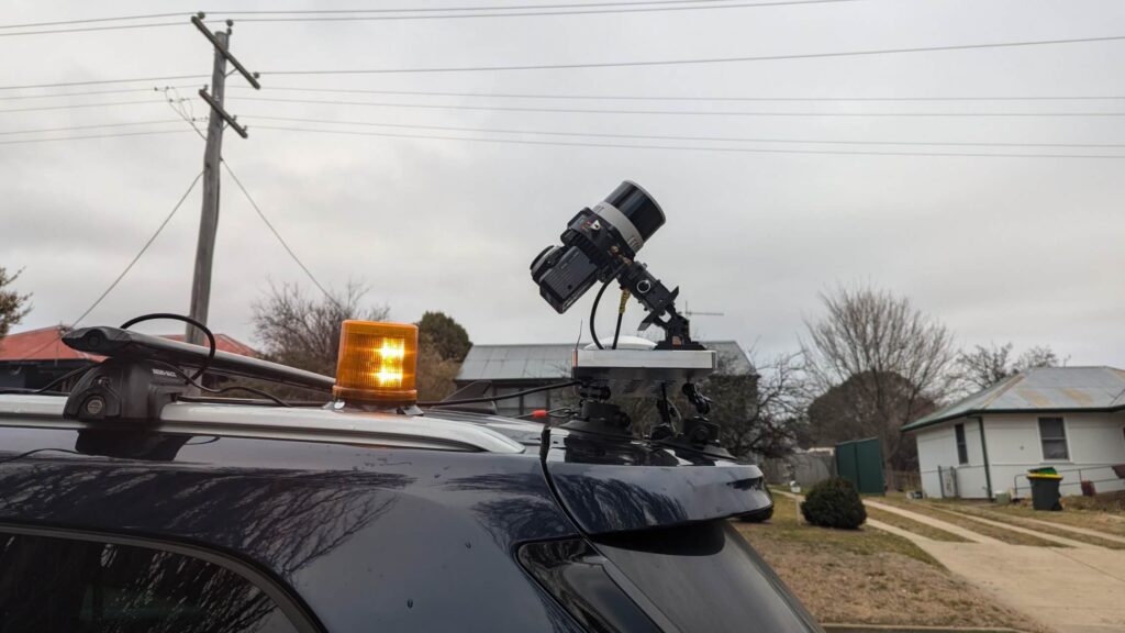
LIDAR works in a similar way to radar or sonar. A beam of light is fired from a sensor and bounces back from whatever hits it. The sensor can then collect information about objects that reflect the beam. The amount of time that it takes for the light to return will determine how far it was from the source. This allows for accurate measurements, which are necessary for gauging severity and estimating required materials and equipment.

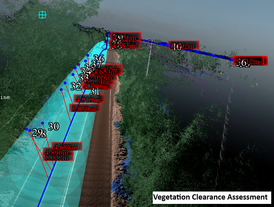
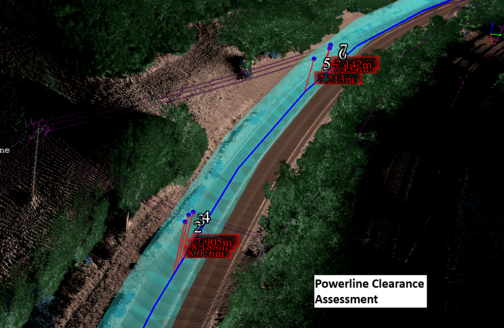
LIDAR is a great option for a road survey, as it can be used day or night, and it delivers precise results. It also provides centimeter level accuracy, which can save a significant amount of time. It can also be used to provide accurate height clearance analysis for bridges and overhead powerlines. 

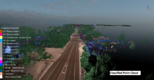
When used for highway and street surveying, the system can be used to produce high-quality 3D models. This can be done by combining the data with the LiDAR360 MLS for feature extractions, like road marks, light poles, road signs and other road infrastructures. It can be produced in several formats, including AutoCAD DXF files and Arc GIS shape files. This allows the engineer to produce a comprehensive road profile, which can be utilized for height clearance analysis and swept-path analysis for over-dimensional load transport. 

While on the construction site, for example in the wind farms, the LiDAR can scan the road, turbine hardstand, and surrounding terrain with centimeter accuracy and georeference coordinates. The data acquired can generate 3D model that can be used for as-built quality control by civil contractor, as well as to get road gradient, horizontal turning radius, crest and sag to allow transport company for transportation feasibility study and selecting the right equipment to bring the wind turbine components to each wind turbine hardstand. 

Furthermore, when compared with previous LiDAR data, it can reveal signs of change in the road’s construction. This information is especially useful when conducting a road survey after a traffic accident or inclement weather events.

Airborne LiDAR can also be used for road surveys. The system can be flown in and out of the field quickly. It can collect information from an entire site in just a few minutes. This can eliminate the need to visit a site more than once, which can save a significant amount of money. It can also be used to create highly accurate terrain models. It can also measure distances, elevations, and other site information.

Regardless of the type of LiDAR that is used, the data that it produces is of great value to both civil and transport engineers. This can help with the planning of projects, as well as the maintenance of existing structures.

Our Solution for LiDAR Road Survey

LiDAR Hardware Equipment for Road Survey - LiMobile

LiMobile with Hesai Pandar 40 LiDAR Sensor is a LiDAR scanner design for road survey, and it can be used to acquire high-quality ground and terrain data on both sides of the road as it is equipped with a high-resolution camera.The integrated vehicle mounting system is highly adaptive to various SUV models. A variety of connection ports are reserved for optional modules, such as panoramic cameras, encoders, horizontal lasers, and many others in order to provide a complete mobile surveying solution.

limobile - mobile lidar scanner - LiMobile-Greenvalley international
LiMobile Vehicle Mounted LiDAR Scanner

Why LiMobile?

  1. 120m detection range with 3cm relative accuracy, which will be sufficient to detect the road infrastructure, vegetation and terrain along the route;
  2. Compatible with light vehicle roof racks, and easy to operate.
  3. Easier operation, Better Field of View and efficiency comparing to aerial lidar survey, LiMobile can scan route without blind spots, and no special permit or skillset (UAV pilot or flying permit) is required;
  4. Can operate with the speed up to 100km/h, which means there is no traffic impact on the roads during site scanning;
  5. Integrated with camera and GNSS module, the system can generate georeferenced and colorized point cloud as well as pictures along the route at 1 scan;
  6. Compatible point cloud processing software and service are also available, to convert the point cloud into road 3D model and import into the software for swept path analysis study;

Road Survey LiDAR Point Cloud Data Analysis - LiDAR360 MLS

LiDAR360 MLS can extra the vector objects from the scanned point cloud data on public and site internal road, and generate GIS shp file, AutoCAD DXF file and 3D object file for load passibility analysis. 

Key Features of LiDAR360 MLS for LiDAR Transport Road Survey

Road and Bridge 3D Model Generation

LiDAR360 MLS is able to generate the 3D Model  road, bridge, and overhead lines, and output with shp, DXF, and object file for transport passability analysis. 

Bridget and road model lidar road survey
bridge Height measurement - lidar road survey

Height Measurement for Bridges and Overhead lines

By using LiDAR360 MLS, the height information of the bridges and overhead lines can be measured easily, and this is important for check the overall height of the truck loads to be transported through. 

Vegetation Trimming Analysis

By inputting the parameters of the truck and its load, LiDAR360 MLS can analyse LiDAR road survey point clound and generate the tree trimming and light pole removal requirements to allow the load to pass through. 

Tree trimming analysis
road gradient measurement, lidar road survey
Bridget and road model 2 - lidar road survey

Road Geometry Measurement

LiDAR360 MLS is also able to measurement the following parameters of the road:

Road gradient;

Road crest & sag value (under development);

Horizontal turning radius; 

Get In Touch With Our Experts About Our LiDAR Services For Road Survey Industry

    1. LiDAR Wind Measurement ServicesLiDAR Powerline Inspection ServiceLiDAR road survey serviceLiDAR BIM ScanningLiDAR HD Mapping Scanning ServiceLiDAR Forest Survey ServiceOther LiDAR Survey Services
    2. PriceTechnical ProposalSolutionsOthers
    3. YesNo

    * Required