Mining Survey Solutions - GVI LiDAR Scanning System and Processing Software
Mining companies around the globe are adopting new digital tools to increase their productivity and capitalize on innovation that is taking place in 3D mining surveying and mapping. GVI provides advanced lidar solutions that help companies build cost-effective, step- change increases in performance that are also sustainable.
GVI LiDAR Mining Survey Solutions
Complte value-added 3D solutions comprising advanced software, sound hardware and deep integration and professional customer centric technical support.
LiDAR data acquisition hardwares:
LiAir: used for above-ground applications;
LiBackpack: used for both underground and above-ground applications
Data Collection
LiAir Series: UAV-based, High-accuracy LiDAR Systems
LiBackpack Series: portable, SLAM-based mobile LiDAR Systems
Data Processing
LiGeoreference: LiAir Data Processing Software
LiFuser-BP: LiBackpack Data Processing and Visualization Software
Data Analysis
LiDAR360 with Forestry Module:
Forest Metric Extraction,
Individual Tree Measurement,
Forest Regression Analysis
Data Aquisition Hardware for Mining Survey
LiAir V70
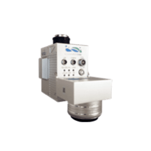
The LiAir V70’s lightweight and portable design offers an wide-angle field of view and fast scanning rate that make UAV-LiDAR data capture efficient. There are few operating restrictions with this device and it has the adaptability to perform effectively in a wide variety of environments.
As a UAV-based 3D laser scanning device, LiAir V70 is well positioned to obtain detailed and accurate measurement data from hard-to-access upper forest canopy regions.
Key Performance Data
| Range Accuracy | ±2 cm |
| Weight | 1.1 kg(Incl.Camera) 0.9kg without Camera |
| Scan Range | 320 m @ 80% Reflectance |
Support
LiBackpack DGC50
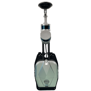
LiBackpack DGC50 is the flagship model in GVI’s LiBackpack Series. This system features dual LiDAR sensors and a panoramic camera that allow users to capture RGB information and generate colored point cloud. The device’s SLAM technology enables it to be used in GNSS-denied zones that are commonly found beneath forest canopies. From this scanning perspective, users can obtain the complete structure of the trunks of the trees and the lowest strata of forest canopies. Furthermore, DBH, canopy coverage, etc. can be readily extracted from this type of ground- based LiDAR data using tools found in GVI’s LiDAR360 TLS Forest Module.
Key Performance Data
| Range Accuracy | ±3 cm |
| Weight | 9 kg |
| Max Ranging Distance | 100m |
Support
Data Processing Software for Mining Survey
LiGeoreference
• Post-process GNSS information collected by LiAir INS
• Generate colorized point cloud with high levels of absolute accuracy
• Reproject point cloud data to a user-specified target spatial reference system
• Calculate and apply boresight corrections to LiAir generated point clouds
Support
LiFuser - BP
• Generate 3D, colorized point clouds from data collected with LiBackpack models that feature an integrated panoramic camera
• Produce 3D point clouds using GVI’s advanced SLAM algorithm
• Adjust data processing parameters based on the surveying conditions to improve accuracy
• Align spatially overlapping point clouds collected at different times
• Easily clean and manage 3D point cloud data
• Display the data in ways that make it easier for the user to interpret
Support
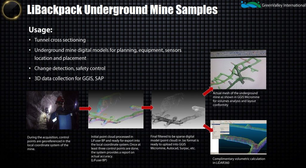
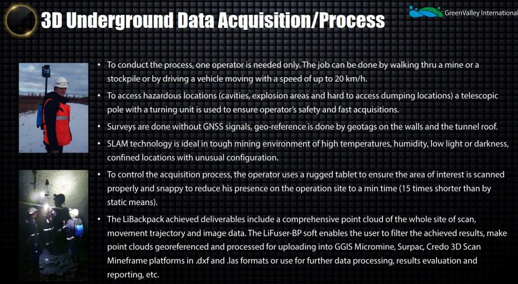
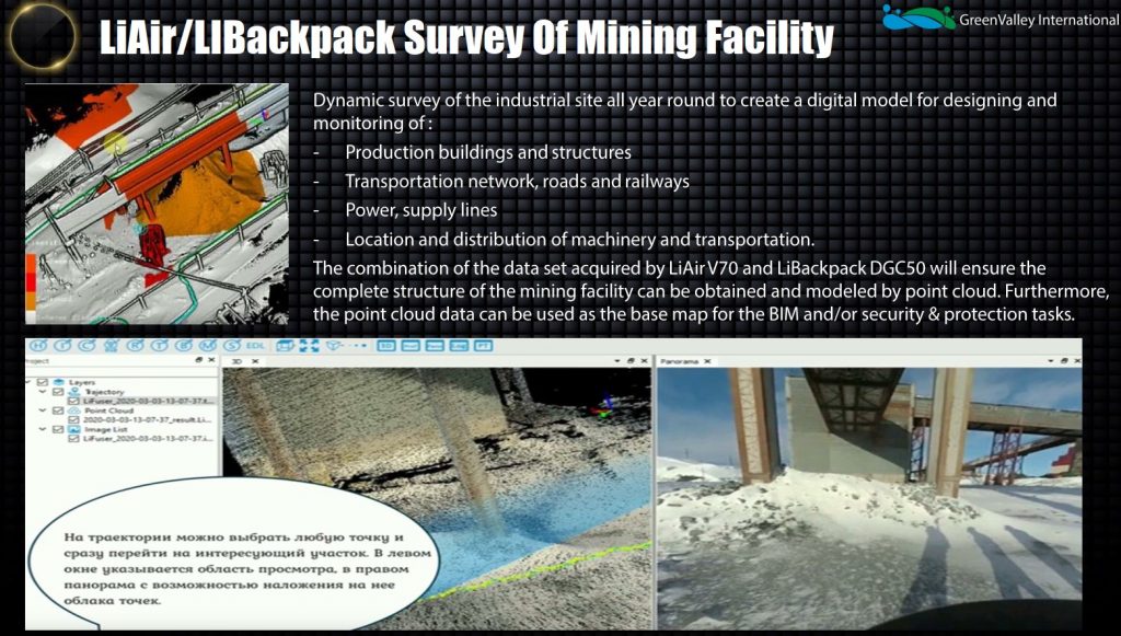
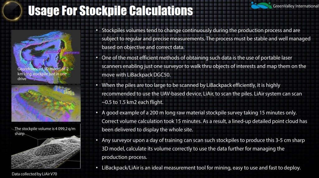
Application Exampls for Mining Survey