Find Us In Booth W60

What is a LiDAR scanner?

One of the first questions our clients understandably ask us is “what is a LiDAR scanner?” In short, a LiDAR (Light Detection and Ranging) scanner is a special device that uses 3D scanning LiDAR technology that can measure distances by illuminating a target with a laser light and analysing the reflected light. A LiDAR scan can be used in various fields, including geography, archaeology, geology, seismology, forestry and atmospheric physics.

LiDAR Scanner Equipment & Solutions for Surveying & Wind Monitoring

LiDAR scanning technology has revolutionised the field of geospatial data collection by providing accurate and efficient 3D mapping solutions. This remote sensing equipment allows surveying instruments to capture precise measurements of objects and environments, producing highly detailed and reliable data.

One of the main benefits of 3D scanning LiDAR technology is its ability to capture large amounts of data in a short amount of time. This is especially useful for mapping and surveying large areas such as cities, industrial sites and natural landscapes. By using LiDAR 3D scanners mounted on aircraft or drones, surveyors can capture millions of data points per second, resulting in a detailed and comprehensive 3D model.

The accuracy of laser scanning technology is also a major advantage. By using the time-of-flight principle, where laser beams are emitted and the time it takes for them to bounce back is measured, surveyors can obtain precise measurements of distances and angles. This level of accuracy is essential for a variety of industries, including construction, engineering and archaeology.

3D mapping solutions based on LiDAR scan technology have many practical applications. For example, the LiDAR scans this technology produces can be used for urban planning, to analyse the impact of new developments on existing infrastructure, and to monitor changes in the built environment over time. In the natural sciences, laser 3D scanning LiDAR technology can be used for environmental monitoring, such as tracking changes in vegetation or the effects of climate change on ecosystems.

In conclusion, laser scanning technology is a powerful tool for geospatial data collection and 3D mapping solutions. Its accuracy and efficiency have made it an essential component of surveying instruments, and it has numerous practical applications in a variety of industries. As LiDAR 3D scanner technology continues to improve, we can expect even more advanced and innovative LiDAR scanning solutions for geospatial data collection and analysis.


Survey LiDAR Hardware

Wind LiDAR Scanning Solutions & Products

Wind LiDAR, also known as wind monitoring LiDAR or laser wind sensing, is a remote sensing device that measures wind speed and direction using optical sensing techniques. This technology has transformed the way we monitor and analyse atmospheric conditions, delivering precise and dependable data for a wide range of applications.

Wind LiDAR has the ability to produce detailed measurements of wind speed and direction at various elevations, which is one of its key advantages. Wind speed detection technologies such as anemometers are confined to measuring at specified heights, whereas wind LiDAR can offer continuous data across the entire height of the atmosphere. This is especially useful in areas like wind energy, where understanding wind patterns at different heights is critical for effective power generation.

LiDAR 3D Scanner App

Our clients can use their smart devices as a LiDAR scanner by installing and using our state-of-the-art LiDAR 3D scanner app that’s capable of scanning and capturing objects. Users can simply hold their device over the object that needs to be scanned and move their device accordingly to create a 3D LiDAR scan.

FAQ About LiDAR Scanner

A LiDAR (Light Detection and Ranging) scanner is a sophisticated device that measures distances and creates precise, three-dimensional information about the shape and surface characteristics of an object or area.

A LiDAR (Light Detection and Ranging) scanner operates based on a simple yet sophisticated principle. Here’s how it works:

  1. Emitting Laser Pulses: The LiDAR system emits laser pulses towards the target. These lasers are typically in the ultraviolet, visible, or near-infrared range.

  2. Travel Time Measurement: Once the laser pulse is emitted, the system measures the time it takes for the light to travel to the target and back to the sensor. This time interval is known as the “time of flight.”

  3. Distance Calculation: The distance to the target is calculated using the time-of-flight data. Since the speed of light is a constant (approximately 300,000 kilometers per second), the distance can be accurately determined by the formula: Distance = (Speed of Light × Time of Flight) / 2.

  4. Creating a Point Cloud: As the LiDAR device scans an area, it collects a large number of these distance measurements from different angles. Each measurement corresponds to a point in space where the laser hit an object. Collectively, these points form a “point cloud,” which is a three-dimensional representation of the area or object scanned.

  5. Data Processing: The point cloud data is then processed using specialized software to create detailed 3D models or maps. This data can be further analyzed for various applications, such as in geographical mapping, urban planning, environmental studies, and autonomous vehicle navigation.

  6. Integration with Other Systems: Often, LiDAR systems are integrated with GPS (Global Positioning System) and IMU (Inertial Measurement Units) to improve the accuracy and reliability of the data. The GPS provides precise location information, while the IMU tracks the orientation and movement of the scanner, especially important in mobile or airborne LiDAR systems.

The cost of a LiDAR (Light Detection and Ranging) scanner can vary widely depending on its specifications, capabilities, and intended use.

Contact our experts to give you the best LiDAR solutions that suit your project. 

Using a LiDAR (Light Detection and Ranging) scanner involves several steps, from setup to data collection and analysis. The exact process can vary depending on the type of LiDAR system you’re using (e.g., handheld, drone-mounted, terrestrial, etc.), but here’s a general overview of the steps involved for LiDAR surveying:

  1. Planning the Survey:

    • Define the objective of the survey (e.g., topographic mapping, forestry analysis, architectural modeling).
    • Determine the area to be scanned and plan the scanning strategy accordingly.
    • If using a mobile or airborne system, plan the flight path or survey route.
  2. Setting Up the Equipment:

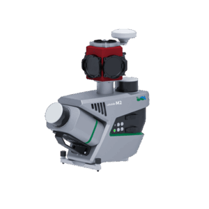
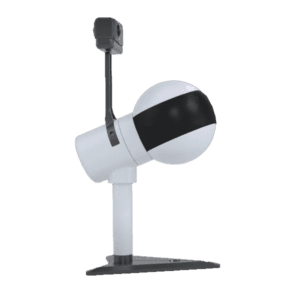
    • Assemble the LiDAR system, ensuring all components like the laser scanner, GPS, and IMU (if applicable) are properly configured.
    • Calibrate the system according to the manufacturer’s instructions.
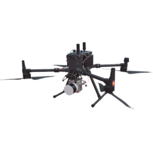
    • For drone-mounted systems, attach the LiDAR unit to the drone and ensure it’s securely fastened.
  3. Conducting the Scan:

    • For stationary terrestrial scans, position the scanner at various points around the survey area to capture data from multiple angles.
    • For mobile or airborne scans, follow the pre-planned route or flight path, ensuring the scanner covers the entire area.
    • Activate the scanner to emit laser pulses and collect data. This is usually done via a control software or remote control.
  4. Data Collection:

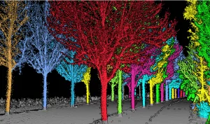
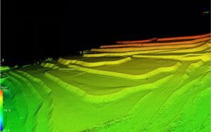
    • The LiDAR system will collect a point cloud, representing the scanned area in 3D.
    • Ensure that the data is being recorded correctly and check for any gaps in coverage.
  5. Data Processing:

    • Download the point cloud data from the LiDAR system.
    • Use specialized software to process and analyze the data. This may include filtering, aligning, and modeling the data.
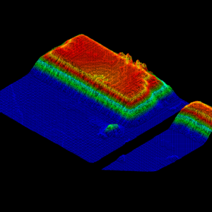
    • Depending on the application, you might generate digital elevation models, 3D reconstructions, or other types of visualizations.
  6. Analysis and Interpretation:

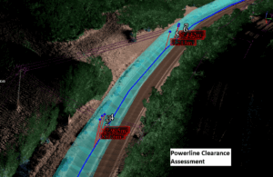
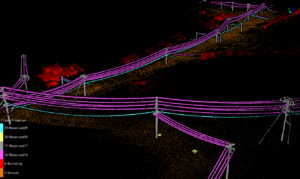
    • Interpret the processed data in the context of your project goals.
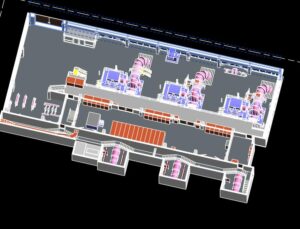
    • For example, in architectural applications, use the data for building modeling; in forestry, analyze tree heights and canopy structures.
  7. Reporting and Further Use:

    • Prepare reports or visualizations as needed.
    • The data can be used for various purposes, such as planning construction projects, conducting environmental impact assessments, or developing autonomous vehicle navigation systems.

The accuracy of a LiDAR (Light Detection and Ranging) scanner can vary based on several factors, but modern LiDAR systems are generally known for their high precision and accuracy. Here are some key points regarding the accuracy of LiDAR scanners:

  1. Resolution and Precision: LiDAR scanners can capture very fine details, with some systems capable of resolving objects just a few centimeters in size. The precision of a LiDAR system refers to the consistency of its measurements, and many LiDAR systems boast very high precision.

  2. Ranging accuracy: The accuracy of LiDAR measurements typically ranges less than 3cm. The more expensive the LiDAR scanner is, normally the more accurate it is. This can also depend on factors such as the type of LiDAR system, the distance to the target, and the reflectivity of the target which will highly determine the maximum detection range of the LiDAR

  3. Factors Influencing Accuracy:

    • Type of LiDAR: Different types of LiDAR (e.g., airborne, terrestrial, mobile) have varying levels of accuracy. Airborne LiDAR tends to have slightly lower accuracy due to the greater distances involved, while terrestrial LiDAR can be extremely accurate for detailed surveys.
    • Environmental Conditions: Factors like atmospheric conditions, weather, and light can affect the accuracy. For instance, heavy rain or fog can scatter the laser pulses and reduce accuracy.
    • Surface Characteristics: The reflectivity and angle of the surface being scanned can also impact measurement accuracy. Surfaces that are very dark, very bright, or at a steep angle to the scanner may result in less accurate measurements.
  4. Calibration and Maintenance: Regular calibration and maintenance of the LiDAR system are crucial for ensuring its accuracy. Over time, components can drift out of their optimal settings, affecting measurement precision. However, most modern LiDAR systems don’t require site calibration for the sensor itself. 

  5. Integration with Other Technologies: The accuracy of a LiDAR system can be enhanced when combined with technologies like GPS and IMU (Inertial Measurement Units). This is especially true for mobile and airborne LiDAR systems. INS with higher performance together with high accuracy LiDAR will delivery data with higher accuracy accordingly. 

Contact Us Today

Call LiDAR Solutions today on 0412 752 033 or contact us online if you have any questions regarding the 3D scanning LiDAR technology we can provide.