
High-Volume Utility LiDAR Surveying for NBN Fibre Connect Program
Large‑Scale Powerline Survey for Ground Clearance and Vegetation Management
Project Location: Riverton / Aparima, Southland, New Zealand
Project Scope: Survey of 75% of township’s LV (Low Voltage) and HV (High Voltage) powerline network for ground clearance and vegetation encroachment assessment
Client: Northpower
Industry: Electricity Distribution / Utility Infrastructure
1. Executive Summary
This case study examines a major powerline surveying project undertaken by LiDAR Solutions in Riverton (Aparima), a coastal town approximately 30 kilometres west of Invercargill in New Zealand’s Southland region. The project was commissioned by Northpower—a 100% New Zealand‑owned integrated infrastructure company with over 90 years of experience in electricity distribution, transmission, and maintenance services—to survey 75% of the township’s low‑voltage (LV) and high‑voltage (HV) powerline network. The primary objectives were to assess ground clearance requirements and identify vegetation encroachment risks across the distribution network.
Faced with a project of substantial geographic scale and complexity—and the additional logistical hurdle of mobilising specialised LiDAR equipment from Melbourne, Australia, to a remote Southland town—LiDAR Solutions deployed vehicle‑mounted mobile LiDAR technology to achieve rapid, high‑precision data collection across the township’s extensive powerline corridors. This approach delivered dramatic efficiency gains compared to conventional surveying methods, enabling the project to be completed within aggressive timeframes while maintaining exceptional data quality. The successful execution of this project confirmed LiDAR Solutions’ capability to deliver complex, large‑capacity surveying assignments for New Zealand’s critical electricity infrastructure sector—across international borders.
2. Project Background
2.1 Northpower: A Leader in New Zealand’s Electricity Sector
Northpower is one of New Zealand’s 29 electricity distribution companies, providing essential electricity and fibre services to more than 63,000 customers in the Whangārei and Kaipara Districts. Beyond its role as a network owner, Northpower also operates as a leading engineering, construction, and maintenance contractor across electricity distribution and transmission, communications, and generation sectors. The company delivers high‑quality outcomes for major utilities including Transpower, Vector, and Powerco, supporting complex projects with precision and innovation across the wider industry.
With over 1,250 skilled professionals and 14 locations across the North Island, Northpower has built a reputation for technical excellence and reliability. The company’s deep understanding of electricity network operations—gained from owning and operating its own distribution network—enables it to bring extensive insights and proven methodologies to projects undertaken for clients.
2.2 The Riverton Township Network
Riverton (Māori: Aparima) is a historic small town located on the south‑eastern shorelines of the Jacobs River Estuary in Southland. Like many rural and semi‑rural New Zealand townships, Riverton’s electricity distribution network comprises a mix of overhead LV and HV powerlines serving residential, commercial, and community facilities. The network is characterised by:
Extensive overhead line corridors traversing both urban streets and peri‑urban areas
Mixed voltage infrastructure, including both low‑voltage (typically 230V/400V) and high‑voltage (typically 11kV and above) lines
Significant vegetation interaction, with trees and shrubs growing in close proximity to powerlines—a common challenge in New Zealand’s temperate climate
Aged infrastructure, requiring regular inspection and maintenance to ensure reliability and safety
2.3 Project Scope and Objectives
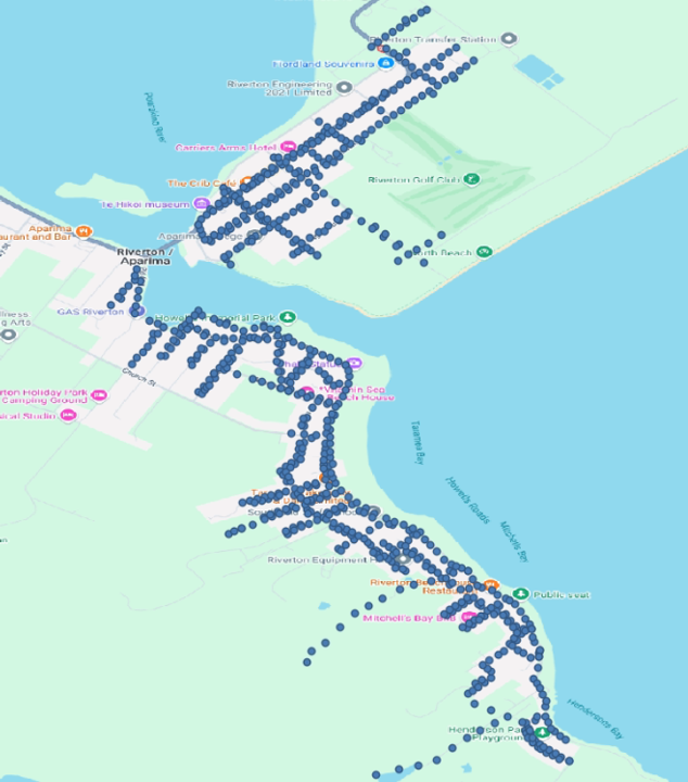
The project required LiDAR Solutions to survey 75% of the township’s LV and HV powerline network. Specific deliverables included:
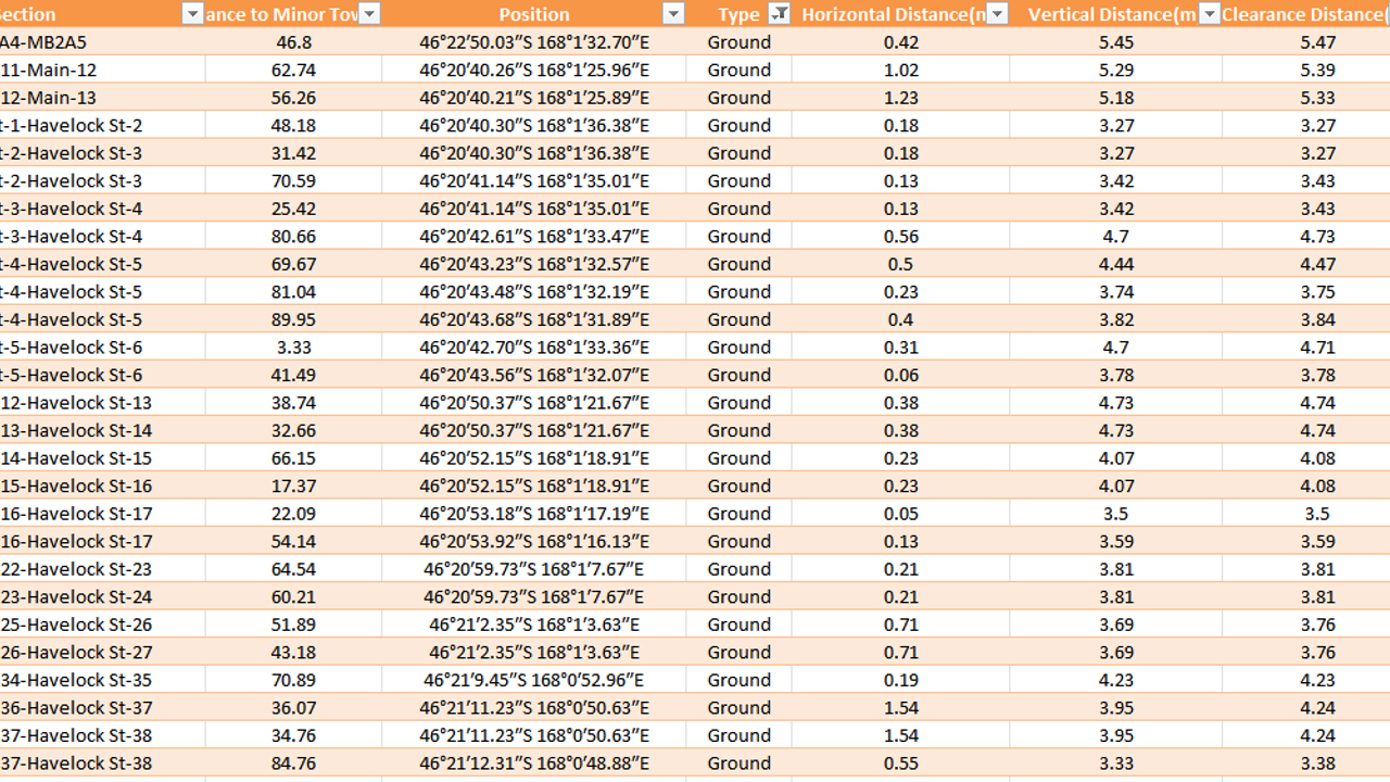
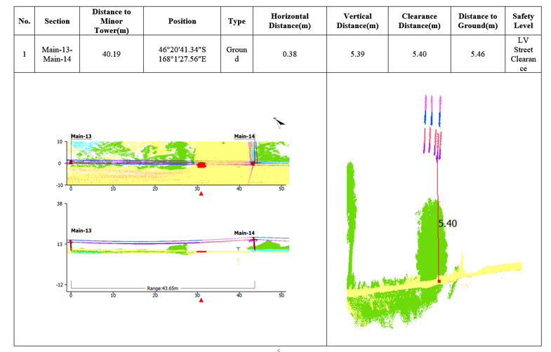
Ground clearance assessment: Precise measurement of vertical clearances between powerlines and the ground, roadway surfaces, and other ground‑level infrastructure
Vegetation encroachment identification: Detection and quantification of vegetation growing within regulated clearance zones around powerlines
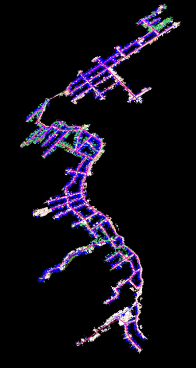
3D corridor mapping: Creation of accurate three‑dimensional models of the powerline corridors, including pole positions, conductor sag profiles, and surrounding terrain
Risk prioritisation: Categorisation of identified encroachments and clearance violations by severity to enable targeted vegetation management
The project was driven by regulatory requirements under New Zealand’s electricity safety framework. Under regulations strengthened in October 2024, minimum safe distances between trees and power lines were increased, with a new “clear to the sky” requirement introduced for certain lines. Electricity distribution companies are required to regularly inspect their powerlines to ensure that no trees are growing too close. The “growth limit zone” varies based on the voltage of the powerline, and any encroaching vegetation must be trimmed back to the notice zone—extending one metre beyond the growth limit zone. These regulatory obligations create an ongoing need for accurate, comprehensive surveying of powerline corridors.
3. The Challenge
3.1 Logistical Challenge: Mobilising LiDAR Equipment from Melbourne to Riverton
One of the most immediate and critical challenges was the international mobilisation of the specialised LiDAR surveying equipment. LiDAR Solutions’ primary vehicle‑mounted mobile LiDAR systems and supporting hardware were based at the company’s headquarters in Melbourne, Australia. Transporting these high‑value, precision‑calibrated assets to Riverton—a remote town on the southern tip of New Zealand’s South Island—presented a multi‑faceted logistical problem:
International shipping and customs clearance: The equipment had to be shipped across the Tasman Sea, requiring coordination with international freight forwarders, customs brokers, and biosecurity authorities. New Zealand has stringent biosecurity regulations to protect its unique environment, meaning all equipment had to be thoroughly cleaned and certified free of soil, organic matter, and pests before entry. Any delay in customs clearance could have derailed the entire project schedule.
Transit time and scheduling: The journey from Melbourne to Riverton involves a sea crossing to either Christchurch or Dunedin, followed by a 300‑400 km road transport leg through the South Island’s variable terrain. Weather conditions—particularly in the southern winter—can cause port closures, ferry cancellations, or road closures, all of which introduce uncertainty. The project timeline left little margin for such disruptions.
Equipment risk and insurance: Mobile LiDAR systems are sophisticated, fragile, and calibrated to sub‑centimetre accuracy. Vibration, shock, or temperature extremes during transport can compromise calibration, rendering the data unusable. Ensuring the equipment arrived in perfect working order required specialised packing, climate‑controlled containers, and comprehensive insurance coverage—adding both cost and complexity.
Backup and redundancy: With only one primary system available for the project, any failure or damage during transit would have caused catastrophic delays. Arranging contingency plans—such as identifying local rental options in New Zealand or rapidly deploying a backup unit from Australia—added another layer of logistical planning.
Local transport and setup: Once in Riverton, the equipment needed to be mounted onto a suitable local vehicle, tested, and calibrated under local conditions. Finding a compatible vehicle with the necessary power supply, mounting points, and road‑worthy certification in a small Southland town was not straightforward.
Overcoming this mobilisation challenge required meticulous planning, early engagement with logistics partners, and flexible contingency strategies—all executed while maintaining the project’s overall budget and timeline.
3.2 Project Scale and Geographic Extent
Beyond the mobilisation, the sheer scale of the surveying task was formidable. Covering 75% of a township’s powerline network meant surveying kilometres of overhead line corridors spanning diverse urban and peri‑urban environments. The network included:
Multiple line routes traversing streets, laneways, and rear property boundaries
Hundreds of power poles requiring individual assessment
Variable line configurations with different voltages, conductor types, and sag characteristics
Diverse terrain conditions, from flat urban streets to undulating peri‑urban areas
Traditional surveying methods—such as manual pole‑by‑pole measurement using total stations or GNSS rovers—would have required weeks or months of fieldwork, with surveyors physically accessing each pole location and taking individual measurements.
The sheer scale of the project—5,500+ individual assets to be surveyed across a geographically dispersed urban area—demanded a surveying approach that balanced speed, accuracy, and cost‑effectiveness. Traditional surveying methods would have required months of fieldwork, extensive manual data entry, and prolonged post‑processing cycles, potentially delaying the NBN design and construction schedule.
4. The Solution
4.1 Vehicle‑Mounted Mobile LiDAR Technology
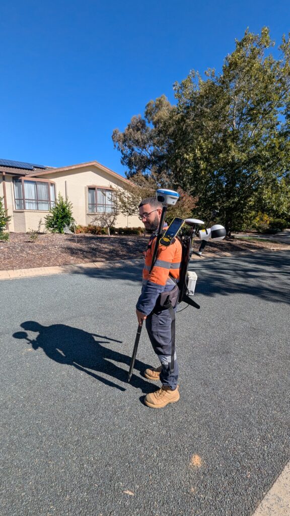
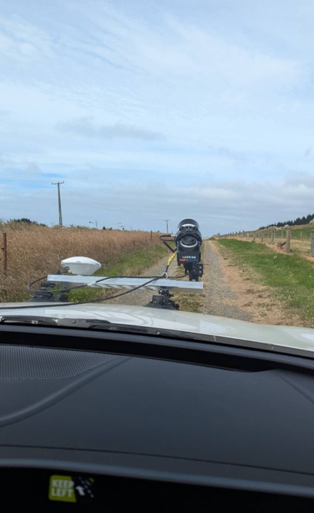
To address the scale, access, safety, and data management challenges—and to mitigate the risks of the international mobilisation—LiDAR Solutions deployed vehicle‑mounted mobile LiDAR scanning systems as the primary data capture technology. This approach represents a transformative advancement in utility corridor surveying.
Mobile LiDAR scanning combines:
High‑speed laser scanning: The vehicle‑mounted system emits millions of laser pulses per second, capturing dense three‑dimensional point cloud data of the surrounding environment
Precise positioning: Integrated Inertial Measurement Units (IMU) and GNSS receivers georeference each data point, ensuring survey‑grade accuracy
Continuous data capture: As the vehicle travels along the corridor, it captures a continuous stream of data—eliminating the need for stop‑start surveying
360‑degree coverage: Multi‑sensor configurations capture data on all sides of the vehicle, including overhead powerlines
4.2 Why Mobile LiDAR Was the Right Choice
Mobile LiDAR offered several critical advantages for the Riverton project:
Dramatic efficiency gains: A single vehicle‑mounted survey could capture data for kilometres of powerline corridor in a single pass. What would have taken weeks using conventional methods could be accomplished in days. The mobile system captures highly comprehensive and precise 3D data of the surroundings using laser‑based remote sensing, producing very realistic powerline models.
Enhanced safety: By keeping surveyors inside the vehicle, mobile LiDAR eliminated the need for roadside work, traffic management, and working at height. This dramatically reduced occupational health and safety risks.
Superior data quality: The dense point cloud captured by mobile LiDAR provides far more information than traditional point‑based surveys. Every powerline, pole, tree, and terrain feature is captured in three dimensions with high precision.
Vegetation penetration: Unlike photogrammetry, LiDAR penetrates vegetation to capture accurate ground surface data. This is essential for accurate clearance assessment, as the system can detect vegetation encroachment and potential hazards.
Minimal disruption: Mobile surveying requires no road closures or significant traffic management, minimising disruption to the township’s residents and businesses.
Repeatable and verifiable: The comprehensive point cloud provides a permanent digital record of the corridor at the time of survey, enabling future comparison and change detection.
4.3 Survey Execution
The survey was executed as follows:
Route planning: Survey routes were planned to cover 75% of the township’s LV and HV network, optimising coverage while minimising travel time
Data capture: The vehicle‑mounted LiDAR system travelled along the planned routes, capturing continuous point cloud data, high‑resolution imagery, and precise positioning information
Quality control: Real‑time data monitoring ensured complete coverage and data quality during the survey
Post‑processing: Raw point cloud data was processed to produce georeferenced, classified 3D models of the powerline corridors
Analysis: Specialised software was used to extract powerline conductor models, measure ground clearances, and identify vegetation encroachments
4.4 Deliverables
LiDAR Solutions delivered a comprehensive suite of outputs:
Classified 3D point clouds of the surveyed corridors
Powerline conductor models showing sag profiles and clearance envelopes
Ground clearance reports identifying locations where clearances fell below regulatory requirements
Vegetation encroachment registers listing trees and vegetation within regulated clearance zones
GIS‑compatible datasets for integration into Northpower’s asset management systems
High‑resolution corridor imagery for visual reference
5. Project Outcomes
5.1 Exceptional Efficiency
The mobile LiDAR approach—enabled by a flawlessly executed mobilisation—delivered dramatic efficiency gains:
Survey completion: The entire 75% network survey was completed in a fraction of the time that would have been required using conventional methods
Reduced field time: Days of vehicle‑based data collection replaced weeks of manual surveying
Minimal disruption: The survey was conducted with no road closures or significant traffic management
Rapid data delivery: Post‑processing and analysis were accelerated by the high‑quality, comprehensive data captured in the field
5.2 Comprehensive Data Coverage
The mobile LiDAR survey captured:
Complete corridor geometry: every powerline, pole, and terrain feature within the surveyed corridors was captured in three dimensions
Accurate clearance measurements: ground clearances and vegetation distances were measured with survey‑grade precision
360‑degree visibility: data was captured from all angles, providing complete situational awareness
Dense point cloud: millions of data points provided exceptional detail and accuracy
5.3 Actionable Intelligence for Vegetation Management
The vegetation encroachment analysis delivered actionable intelligence for Northpower’s vegetation management program:
Identification of priority risks: encroachments were categorised by severity, enabling targeted intervention
Precise location data: each encroachment was accurately located, enabling efficient dispatch of vegetation management crews
Regulatory compliance: the survey provided documented evidence of compliance with New Zealand’s electricity safety regulations
Baseline for future monitoring: the comprehensive dataset provides a baseline for future change detection and trend analysis
5.4 Enhanced Asset Management
The survey outputs directly supported Northpower’s asset management objectives:
Accurate asset records: pole positions and network geometry were captured with survey‑grade accuracy
Informed maintenance planning: clearance and encroachment data enabled prioritisation of maintenance activities
Risk reduction: identification and remediation of clearance violations reduced the risk of power outages and safety incidents
Regulatory assurance: the comprehensive survey provided documented evidence of regulatory compliance
6. Conclusion
The Riverton powerline survey project represents a compelling demonstration of LiDAR Solutions’ capability to execute complex, large‑capacity surveying assignments for New Zealand’s electricity distribution sector—even when faced with the significant logistical hurdle of international equipment mobilisation from Melbourne.
By deploying vehicle‑mounted mobile LiDAR technology, and by meticulously planning and executing the cross‑Tasman transport, customs clearance, and local setup, LiDAR Solutions transformed what could have been a logistically overwhelming project into a streamlined, efficient operation. The mobile approach delivered dramatic efficiency gains—replacing weeks of conventional fieldwork with days of vehicle‑based data collection—while simultaneously enhancing safety, data quality, and comprehensive coverage.
The successful completion of this project confirmed LiDAR Solutions’ position as a trusted partner for utility infrastructure surveying in New Zealand and across the broader Australasian region. Our ability to combine advanced technology with robust project management and international logistics expertise ensures we can deliver accurate, reliable, and actionable spatial data—even for projects of substantial geographic scale and complexity, regardless of where our equipment originates.
As New Zealand’s electricity sector continues to face increasing demands for network reliability, safety, and regulatory compliance, LiDAR Solutions stands ready to bring the same innovation, efficiency, and quality to projects of any scale across the country—and beyond.