SLAM & Backpack LiDAR Scanners Australia - Mobile 3D Mapping
Revolutionize your site surveys with 3D SLAM laser scanning technology—the advanced mapping solution delivering mm-precision 3D maps for Australia’s toughest projects. Our SLAM LiDAR systems capture millions of data points per second, generating high-accuracy digital twins of complex environments—indoors, underground, or GNSS-denied.
Speed & Cost Savings Automate surveys with backpack SLAM scanners or wearable LiDAR systems, slashing field time by 80% versus traditional methods. Ideal for rapid mine cavity mapping, stockpile volumetrics, and BIM compliance scans.
Unmatched Accuracy in Hazardous Environments Deploy underground SLAM mapping for mines or tunnels without GPS. Our rugged wearable LiDAR Australia solutions deliver real-time, millimetre-accurate point clouds—critical for 3D modelling and infrastructure planning.
Versatile Site Intelligence From urban development surveys to construction progress tracking, generate actionable 3D models for:
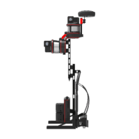
 Backpack LiDAR Scanner
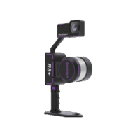
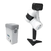 Handheld LiDAR Scanner