
Transform Your Construction Project with Precision LiDAR Scanning Solutions in Australia
Accurately capture, model, monitor and manage your construction site with cutting-edge LiDAR technology. LiDAR Solutions Australia provides comprehensive terrestrial and aerial scanning services using handheld, backpack, drone, and vehicle-mounted systems to deliver accurate data, driving efficiency, safety, and cost savings from planning to completion.
LiDAR Scanning for Construction
A LiDAR (light detection & ranging) scanner is a great tool to see the entire construction site. This technology can identify problems that need repair or renovation and help you reduce costs through earthwork volume calculation and site progress tracking.
The LiDAR scanner can also be used to create a 3D model. This model can be used for planning and building around historical structures. It can also help you to understand the terrain and identify any potential problems in construction.You can use LiDAR scanners for detailed survey data, in addition to the BIM process. This data can be used to make critical calculations such as calculating material requirements. This will make it easier for your team to complete projects efficiently.
A LiDAR scanner can be used to reduce material scrap and overages. It is also useful in helping construction teams comply with construction regulations. LiDAR scanners can be used to help you design the right building for your needs.
Before you start any type of laser scanning project, it is essential to have a site map. You can use the scanner’s range and accuracy to gather the information you require. This data can be used for accurate plans. Point cloud data, which is the data from the scanner, can also be used to create a 3-D model of the construction site.
Advanced LiDAR Technology Solutions for Every Site Challenge
We deploy a fleet of advanced sensors to capture precise data in any environment, ensuring the right tool for your project’s unique demands.
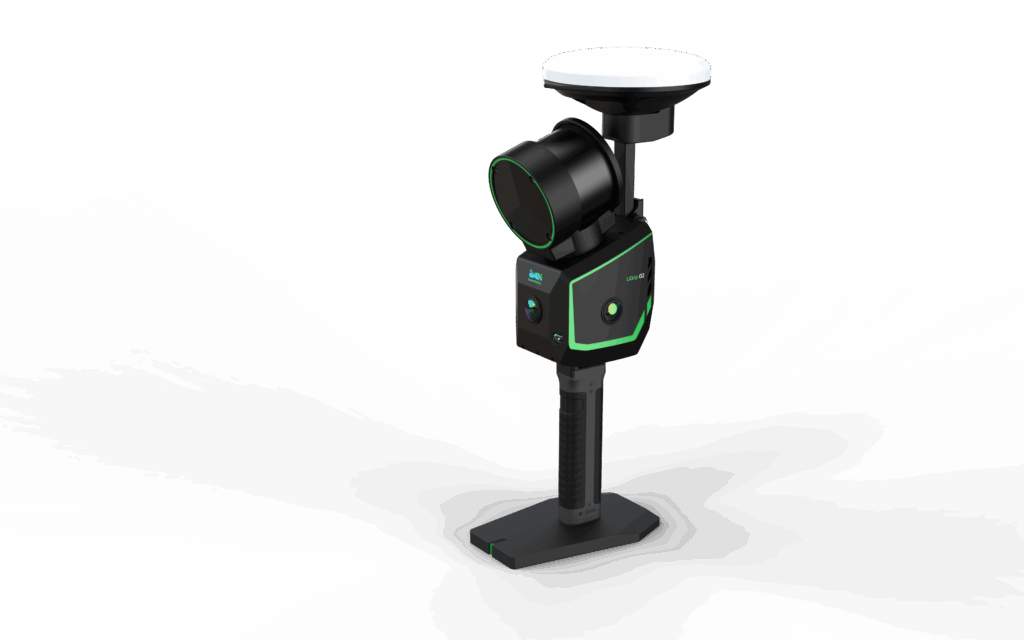
Handheld & Backpack SLAM LiDAR Systems
Navigate complex, enclosed, or GPS-denied environments with unparalleled agility. Our wearable SLAM (Simultaneous Localization and Mapping) systems are perfect for rapid interior scans, dense urban sites, underground utilities, and heritage structures. They capture millions of data points per second while in motion, slashing field time by up to 80% compared to traditional methods.
Best For: Indoor spaces, complex interiors, GNSS-denied areas
Key Advantage: Agility and speed in confined spaces
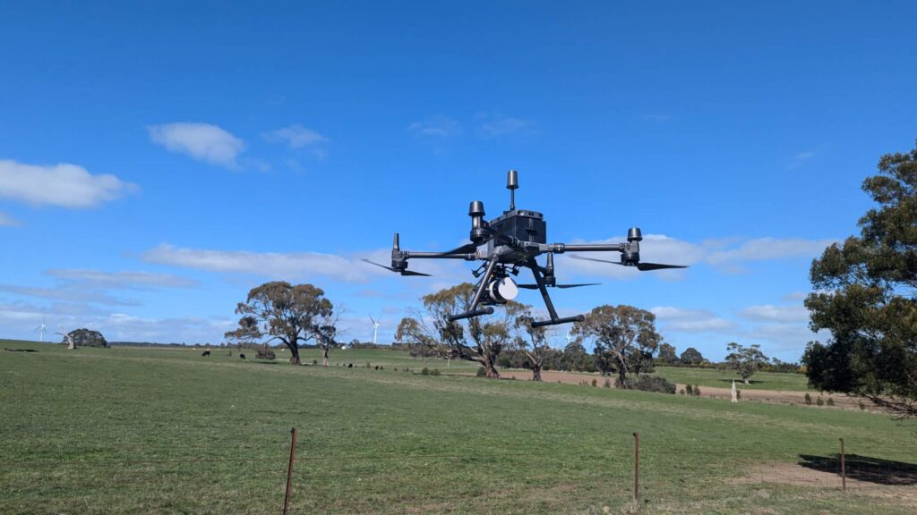
Drone-Mounted Aerial LiDAR Scanning
Conduct rapid, safe topographic surveys of large or inaccessible areas. Our UAV LiDAR systems efficiently map slopes, contours, stockpiles, and roofs, generating accurate terrain models even in vegetated areas by penetrating canopy cover. This method is ideal for initial site planning, volumetric calculations, and monitoring progress over extensive project footprints.
Best For:Large topographic surveys, stockpiles, inaccessible areas
Key Advantage:Rapid, safe coverage of large areas
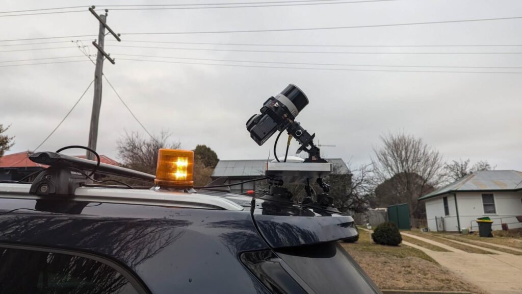
Vehicle-Mounted Mobile Mapping Systems
Capture high-resolution geospatial data along linear corridors at road speed. Our vehicle-mounted systems are the optimal solution for surveying transport routes, highway infrastructure, rail corridors, and urban planning projects, delivering vast amounts of geo-referenced point cloud data efficiently.
Best For:Roads, highways, rail corridors, urban models
Key Advantage:High-speed, long-distance corridor mapping
Key Applications of LiDAR in the Construction Industry
LiDAR data transforms into actionable intelligence across the entire project lifecycle.
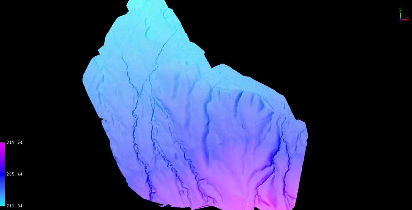
Pre-Construction: Planning & Design Validation
Begin with certainty. Use our high-accuracy topographical surveys and existing condition models to inform design, calculate earthworks, and identify potential site challenges before breaking ground, reducing unforeseen costs and delays.
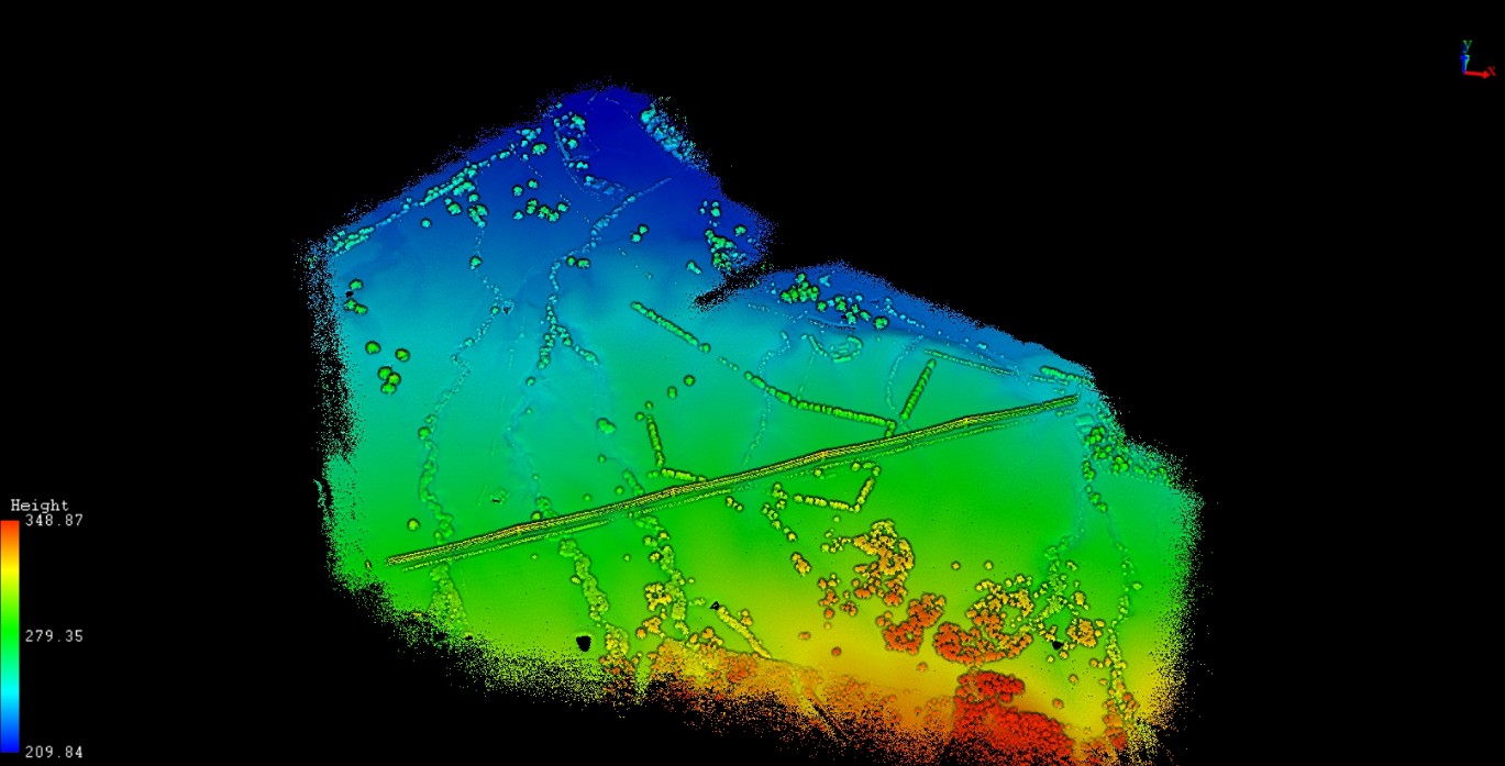
Project Example: Topographic survey for a solar farm development project in Victoria
Deliverables: Classified point cloud, DEM, Contour, and images
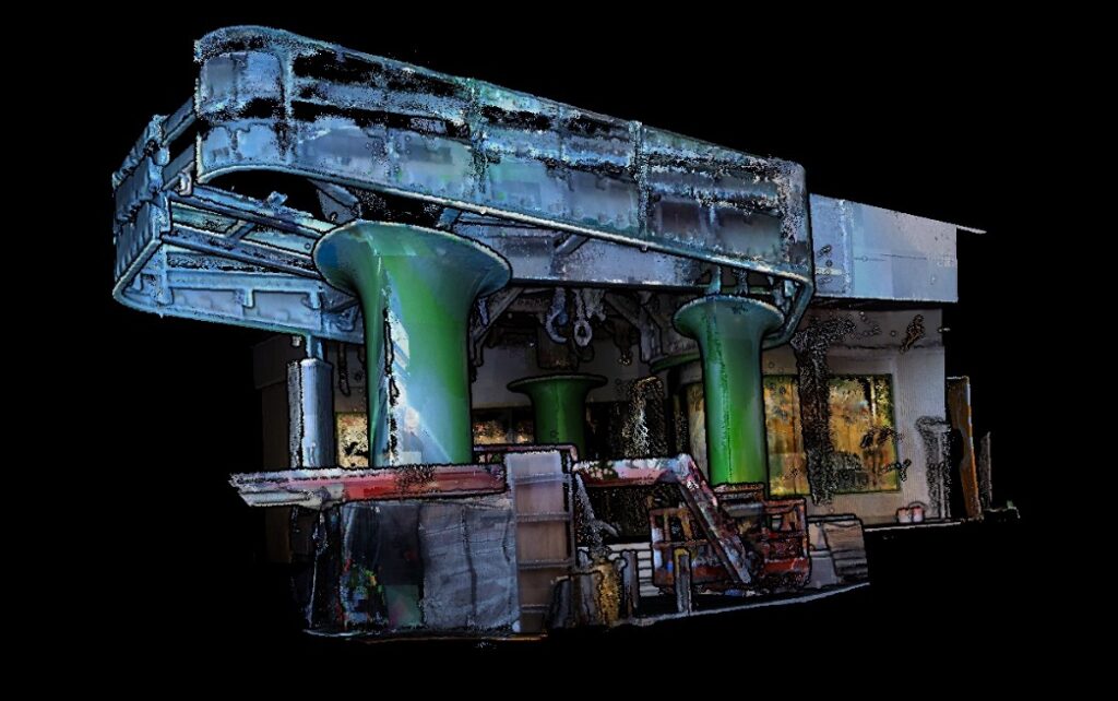
During Construction: As-Built Verification & Progress Tracking
Ensure adherence to design intent. Regular LiDAR scans create precise as-built models that can be compared directly against BIM plans for clash detection, verifying the placement of structural elements, MEP (Mechanical, Electrical, Plumbing) systems, and more. This enables real-time progress tracking and quality assurance.
Project Example:The Royal Dental Hospital of Melbourne as-built survey
Deliverables:Vector perimeter in AutoCAD format
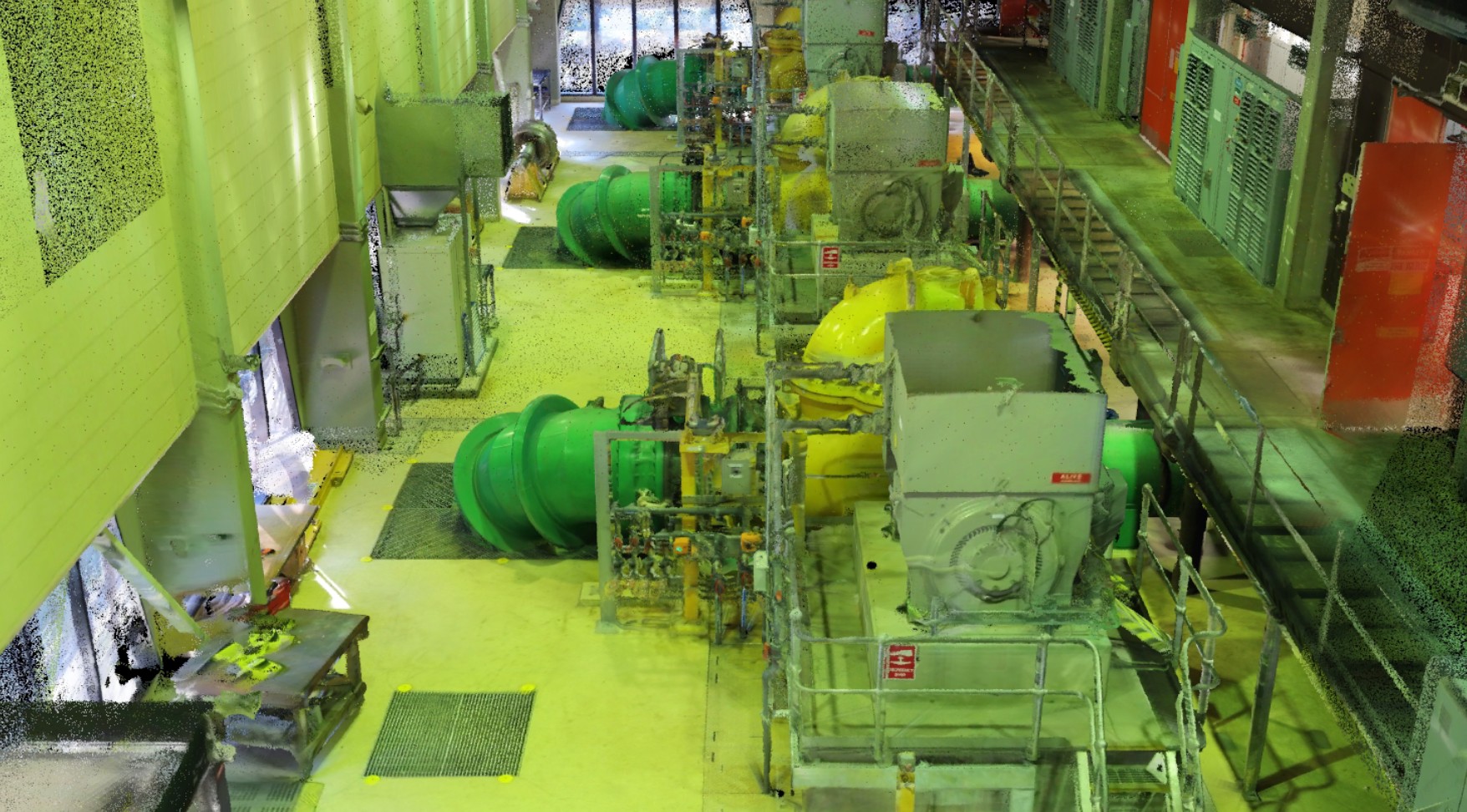
Post-Construction: Final As-Built Documentation & Asset Management
Deliver perfect project records. We provide comprehensive, dimensionally accurate as-built models and drawings essential for owner handover, facility management, and future renovation work, creating a valuable digital twin of the completed asset.
Project Example: a facility in Melbourne Water
Deliverables: high precision point cloud and BIM model (Revit 2024)
Contact Us
Actionable Deliverables for Your Construction Project
We transform raw point cloud data into the specific formats your team needs to work effectively.
Adopting LiDAR technology delivers a clear return on investment by mitigating risk and enhancing operational efficiency.
Unmatched Accuracy & Reduced Rework: Achieve millimeter-level precision in measurements, minimizing errors and costly corrective work during construction. Early clash detection alone prevents significant budget overruns.
Dramatic Time & Cost Savings: Capture millions of data points per second, completing surveys in hours instead of days. This efficiency reduces labor costs, minimizes site disruption, and keeps projects on schedule.
Enhanced Safety & Accessibility: Remotely scan hazardous, unstable, or difficult-to-access areas like tall structures, confined spaces, or active work zones, keeping personnel out of harm’s way.
Improved Collaboration & Decision-Making: Share rich 3D visualizations and models with all stakeholders—architects, engineers, contractors, and clients. This creates a single source of truth, improves communication, and facilitates data-driven decisions.
High-Density 3D Point Clouds
The foundational dataset in formats like LAS/LAZ, usable across most industry software.
Accurate 2D Drawings & CAD Plans
Extract precise floor plans, elevations, and cross-sections from the scan data.
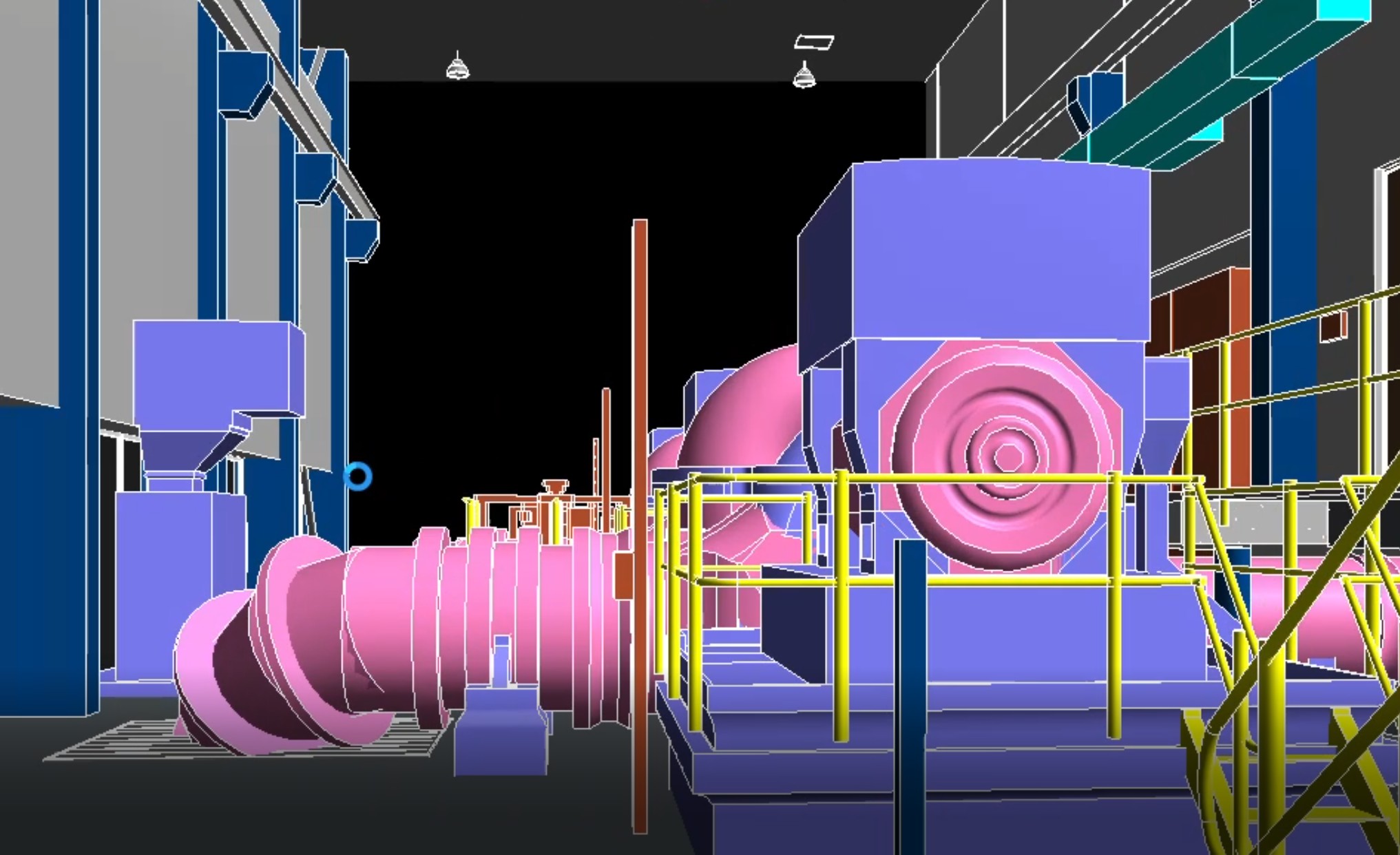
Detailed 3D BIM/Revit Models
Intelligent, object-oriented models created through Scan-to-BIM processes for design, coordination, and management.
Digital Surface & Terrain Models (DSMs/DTMs)
ssential for topographic analysis, cut/fill calculations, and drainage planning.
Comprehensive Report
Including deviation analysis (as-built vs. design), volumetric reports, and progress summaries.
Benefits of Using LiDAR for Construction
Adopting LiDAR technology delivers a clear return on investment by mitigating risk and enhancing operational efficiency.
Unmatched Accuracy & Reduced Rework: Achieve millimeter-level precision in measurements, minimizing errors and costly corrective work during construction. Early clash detection alone prevents significant budget overruns.
Dramatic Time & Cost Savings: Capture millions of data points per second, completing surveys in hours instead of days. This efficiency reduces labor costs, minimizes site disruption, and keeps projects on schedule.
Enhanced Safety & Accessibility: Remotely scan hazardous, unstable, or difficult-to-access areas like tall structures, confined spaces, or active work zones, keeping personnel out of harm’s way.
Improved Collaboration & Decision-Making: Share rich 3D visualizations and models with all stakeholders—architects, engineers, contractors, and clients. This creates a single source of truth, improves communication, and facilitates data-driven decisions.
Ready to Build with Precision?
Contact LiDAR Solutions Australia today for a consultation. Our experts will scope your project, recommend the optimal scanning method, and provide a clear pathway to more efficient, accurate, and successful project outcomes.