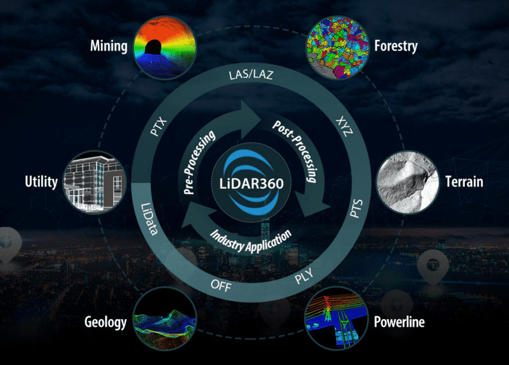
LiDAR 360 - LiDAR Point Cloud Processing Software Suite for Australian Market
We are bringing the advanced lidar point cloud processing software LiDAR360 into Australia which lays the foundation for the entire software suite. With TB-level processing power, the Framework contains tools required for effectively interacting and manipulating LiDAR point cloud data. The functions include data management, automatic strip alignment, and point cloud classification. It also allows users to upgrade to application-specific modules such as terrain, ALS/ TLS Forestry, and Geological Analysis. In the latest version 5.0, the powerline module is also added to LiDAR360 to allow users to conduct professional analysis on powerline point cloud data, such as classification, danger point detection, and so on.
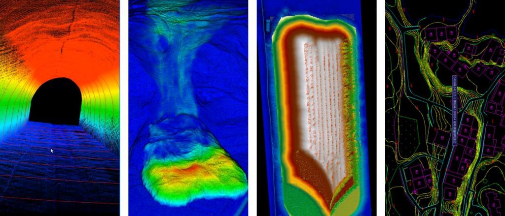
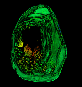
The terrain module provides a series of automatic and manual-editing tools for classifying ground points from LiDAR point clouds.
Addtionally, it also provides a set of GIS tools for interpolating surface models (e.g., digital elevation model/DEM, digital surface model/DSM), and visualizing and editing them in 3D. Furthermore, it contains tools for repairing surface models from spikes and holes.
Furthermore, It allows users to analyze the terrain model to generate derivatives from the surface models, e.g. slope, aspect, and roughness. In the latest version, the change detection and deviation analysis functions have better support users’ needs in different fields, e.g., disaster monitoring and land-use change analysis.
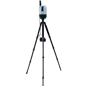
LiDAR 360 LiDAR Point Cloud Software - Tutorial For Terrain Modelling
LiAir 360 - Powerline Inspection LiDAR Point Cloud Software Module
Overview
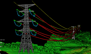
LiDAR360 powerline module can automatically classify power line and tower lidar point clouds, perform real-time power line analysis, establish a sample library of machine learning classification algorithms, reproduce the terrain, landforms, and ground features in the transmission line corridor accurately and effectively.
Additionally, the data can be managed in a unified manner and combined with the relevant operating procedures of the transmission line to analyze the crossing, tree barriers, geology of the line, and complete the three-dimensional visualization of the transmission line corridor, finally achieve fast and efficient power line hazard detection and investigation in the grid system.
Accurate Modelling
Accurate and precise 3D modeling of towers, wires and ground features to help analyze defects such as tree barriers and crossovers in the line channel
Automation
Quickly detect dangerous trees that exceed the safe distance of the transmission line, and accurately calculate the hidden dangers in the channel network.
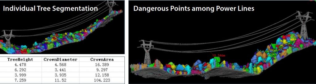
Support Tree Segmentation
Supports tree segmentation along the power transmission channels, quickly detects the number, location, height, crown width and other information of hidden tree hazards, accurately calculates the amount of felling, and provide guidance for the field work of hazard investigation in the power grid industry.
LiDAR 360 - ALS/TLS Forestry LiDAR Data Processing Software Module
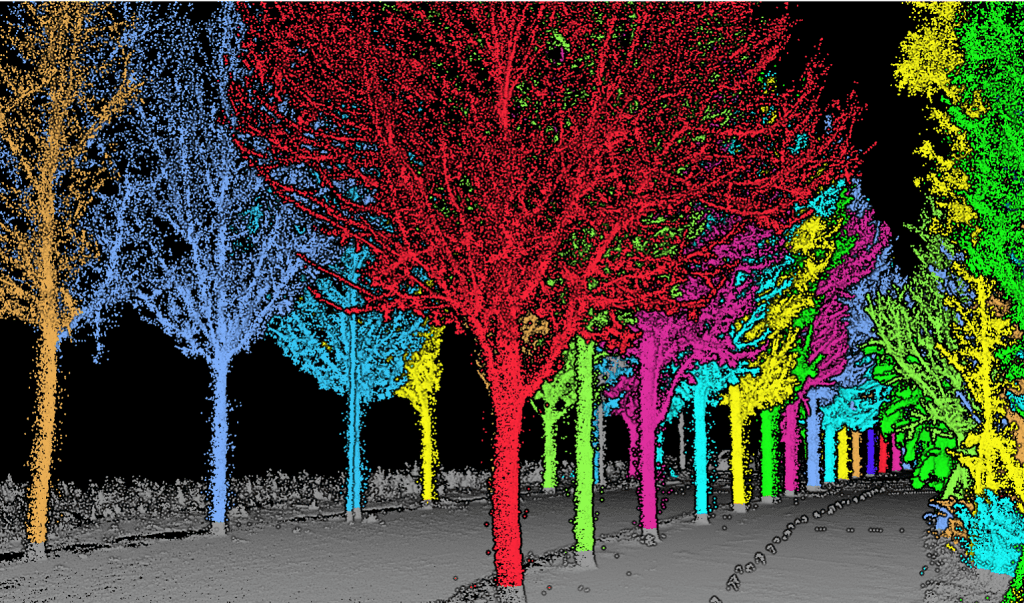
The forestry module contains tools to process lidar point cloud data acquired from aerial laser scanning (ALS) systems (e.g., LiAir, LiEagle), terrestrial laser scanning (TLS) systems (e.g., LiBackpack), and mobile laser scanning systems (e.g., LiMobile). This module provides effective individual tree segmentation and editing tools for all kinds of point cloud data. And users can recover the topographic information with denormalization tool after the segmentation and editing.
Individual Tree Segmentation
Segment individual trees based on point cloud from both aerial and terrestrial LiDAR systems. Supports both CHM-based and point cloud based segmentation algorithms. After the segmentation, users can manually modify the segmentation result to improve accuracy. And then recalculate the individual tree metrics based on the modified result.
Forest Metrics
Automatically calculate forest metrics including elevation, intensity, canopy cover, LAI, etc., and provide regression tools to derive parameters of forests that cannot be directly extracted from LiDAR point clouds, such as biomass and stem volume.
Individual Tree Segmentation
Automatically calculate individual tree parameters based on the segmented point cloud including tree location, tree height, diameter at breast height (DBH), crown area, crown diameter , crown area and so on.
LiDAR 360 - Tutorial - Forestry Module
LiAir 360 - Mine LiDAR Point Cloud Processing Software Module
Overview
Based on the real-time 3D point cloud data of mine on multi-platform, such as aerial and backpacks, the LiDAR360 measurement and terrain analysis modules can realize the mining path change detection of the open-pit mine, the quantitative analysis of the mining operation volume and the auxiliary decision-making of mining planning. At the same time, regular inspection and the analysis of the underground mine tunnel can be achieved to assist accident early warning and decision-making.
Economic and Environmental Evaluation of Mine Subsidence Area
Accurately measure the development of soil erosion on slopes and the volume of sand dunes.
Tunnel section analysis
Based on the point cloud data, highly accurate and precise 3D models of the tunnel will be generated in LiDAR360, and the differences between the standard (reference) section and the scan (point cloud derived) section are compared to monitor the tunnel deformation.
Mine pile volume measurement
The 3D laser scanning system is used to observe the deposits and quickly obtain the 3D coordinates of the surface points of a large number of mine piles. The software can accurately calculate the volume of the mine piles based on the principles of calculus.
LiPowerline - Powerline LiDAR Point Cloud Analysis
Overview
LiPowerline offers an intuitive and highly efficient solution for power line inspection from LiDAR point clouds and high-resolution imagery. This software includes powerful tools for the automatic and manual classifying of power lines, transmission towers, vegetation, buildings, and other objects of interest. The program can be used to automate the detection of user-defined danger points (e.g., vegetation encroachment and tree fall hazards). Built-in reporting functions allow users to quickly generate detailed project reports, and results can be exported as KML formatted files.
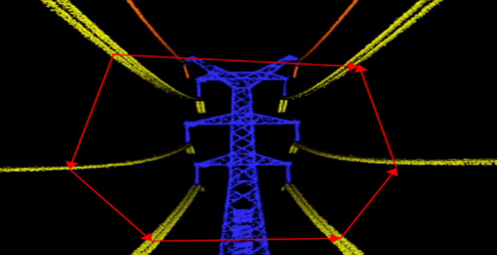
When carrying out detailed transmission tower inspections with drones, operators can define a flight plans that consider transmission tower designs based on previously collected point cloud data. The point cloud data is used to develop pre-planning flight routes that target the main components of the tower during high-resolution image capture.
• Deep learning tools that automate the classification of the transmission tower and conductors in point cloud data • Automated ground and noise point classification routines • 2D and 3D profile editing tools to assist users during point cloud classification
— Real-Time Working Conditions Analysis
• Individual tree segmentation by span/section • Extract danger points along power lines • Detect individual tree information such as location, height, crown size, etc.
— Simulate & Predict Environmental Variabilities
• Semi-automated tools for vectorizing insulators, power lines and transmission towers • Simulate influences of tree fall, expected individual tree growth, wind, ice-loading, and air temperature on conductor sag and sway under user-defined environmental conditions
— Inspections Based on LiDAR Data
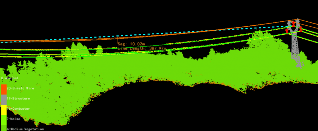
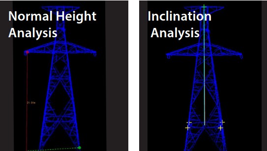
• LiPowerline has been developed to with the goal of extracting the information on corridor/right-of-way as well as asset (e.g. conductors and transmission towers) from LiDAR data. This information can then be used in subsequent analyses including those that examine phase-spacing, normal height and inclination conditions, as well as the impacts of different environmental conditions on conductor sag.
Conductor Sag Analysis
Phase Spacing Analysis
— Detailed Transmission Tower Inspections
• Detailed transmission tower inspections support capturing a large set of high-resolution images of the main components of the tower, and typical issues that analysts identify using drone-based imagery include structural issues, missing and backed-out cotter pins, cracked insulators, vegetation concerns and so on. • In short, you can use our system to identify hard-to-find maintenance issues—before they degrade performance or cause a critical failure. • Moreover, LiPowerline contains functions that allow users to plan efficient transmission tower inspection flight routes. These flight plans can then be imported into the ground control software. These flight route planning functions can significantly reduce the cost of inspections by improving data collection efficiency. Users can also simulate the flight in the point cloud data before heading to the field in order to determine if the proposed route is safe or not to fly.