
What is Lidar and How Does It Work? A Comprehensive Guide to Lidar Technologies
Lidar technology, or Light Detection and Ranging, has revolutionised various industries, including autonomous vehicles, geographic surveying, environmental monitoring, and more. If you’re looking to understand how lidar works, its key components, and its diverse applications, you’ve come to the right place. In this detailed guide, we’ll explore what lidar technology is, how it functions, and why it’s gaining traction in many sectors.
In addition, we’ll compare lidar vs radar, highlight lidar solutions, and help you understand the importance of choosing the right lidar company for your needs. So, whether you’re in need of lidar solutions for your business or simply curious about the technology, this blog will provide you with a complete understanding of lidar technologies.
What is Lidar? Understanding Lidar Technology
Lidar (Light Detection and Ranging) is an advanced remote sensing technology that uses laser light to measure distances to objects or surfaces. By sending pulses of light towards a target and measuring the time it takes for the light to reflect back, lidar systems create highly accurate 3D models and maps of the surface and objects in their environment.
This technology is widely used in various applications where precise, non-contact measurements are needed. Unlike traditional survey methods that may involve physical contact, lidar technologies allow for detailed mapping and scanning from a distance, offering benefits like increased efficiency, safety, and accessibility to hard-to-reach locations.
Some common examples of lidar applications include:
- Geographical and topographical surveys.
- Autonomous vehicles that use lidar for obstacle detection.
- Forestry and agricultural mapping.
- Archaeological site analysis.
The ability to capture vast amounts of data quickly and accurately makes lidar one of the most powerful tools in many sectors.
How Does Lidar Work? The Core Components of Lidar Technology
To understand how lidar works, it’s important to explore the core components that make up a lidar system. Below are the fundamental elements:
- Laser: The Heart of Lidar Technology
At the core of any lidar system is the laser. The laser emits light pulses that travel at the speed of light towards a target. These pulses are emitted thousands of times per second, providing detailed readings of surfaces, objects, and terrain. The accuracy of these pulses is what allows lidar to create such detailed, high-resolution 3D models.
- Scanner: Capturing Data from Different Angles
A lidar scanner is the component that directs the laser pulses toward the target. It helps collect data by rotating and scanning different parts of the environment, ensuring that no area goes uncovered. The scanner can be mounted on a range of platforms, from ground-based systems to drones and even vehicles, which enhances its flexibility for various applications.
- Receiver: Capturing Reflections for Distance Measurement
Once the laser pulse hits an object, it reflects back to the lidar system. The receiver captures the reflected pulse and calculates the time it took for the light to travel to the target and back. Using this time, the system calculates the exact distance from the sensor to the object or surface.
- GPS and IMU: Ensuring Accuracy and Precision
For lidar systems to provide highly accurate data, they often incorporate GPS (Global Positioning System) and IMU (Inertial Measurement Unit) technologies. These components help track the position and orientation of the lidar system as it scans its environment, ensuring that the measurements are precise and correctly mapped to the real-world coordinates.
- Software: Processing and Analysing Data
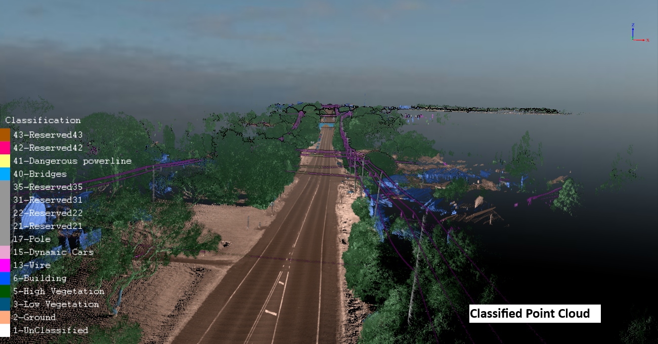
Once the data is captured, lidar software is used to process and analyse the measurements. The software creates 3D point clouds that represent the scanned area, providing a detailed map of the environment. These point clouds can then be converted into 3D models, which are used in mapping, terrain analysis, and object detection.
The combination of these components allows lidar technology to deliver highly accurate results in real-time, making it a valuable tool for numerous applications.
Applications of Lidar Technology
Lidar technologies are used in a variety of industries due to their ability to capture data with high precision. Here are some of the most common applications:
- Autonomous Vehicles
One of the most exciting applications of lidar technology is in autonomous vehicles. Self-driving cars rely heavily on lidar to detect obstacles, map their surroundings, and navigate safely. Lidar systems in autonomous vehicles provide real-time data, allowing the vehicle to make split-second decisions based on the environment. Without lidar, these vehicles would be unable to accurately detect and respond to objects, pedestrians, and other hazards.
- Geographic and Environmental Mapping
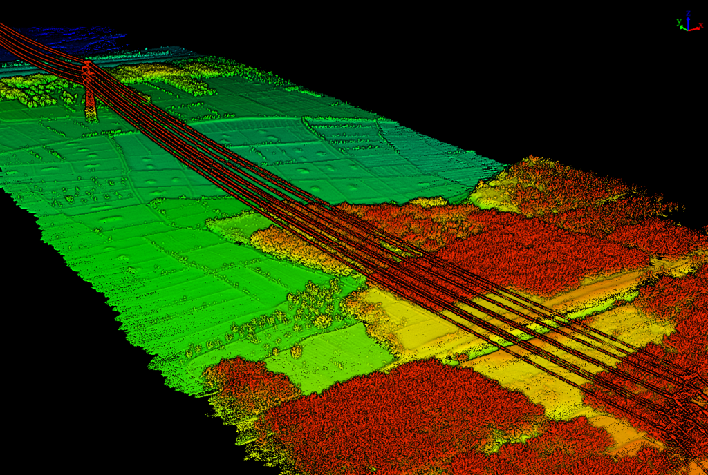
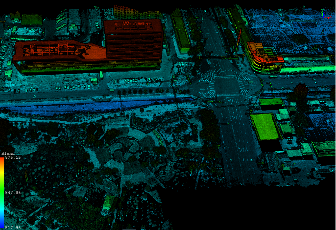
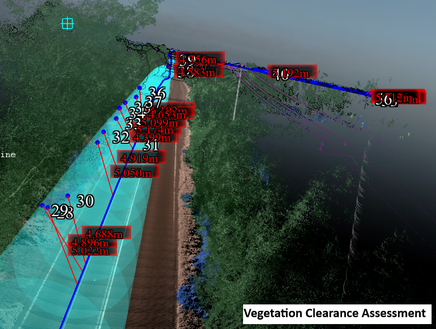
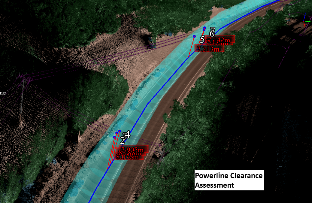
Lidar is widely used in geographic surveying and environmental monitoring to create highly detailed maps of terrains, forests, and urban areas. Unlike traditional methods, lidar solutions can penetrate forest canopies, allowing researchers to map both the forest floor and the vegetation above it. This is crucial for environmental studies, habitat monitoring, and land use planning.
- Forestry and Agriculture
In forestry and agriculture, lidar technologies are used to measure tree height, biomass, and forest density, providing critical data for conservation and land management. Lidar is also useful for monitoring crop health, assessing soil conditions, and improving agricultural efficiency.
- Archaeology and Cultural Heritage
Lidar technology has been used in archaeology to uncover ancient ruins and structures that would otherwise be difficult to detect. For example, lidar has played a significant role in uncovering hidden Mayan cities beneath the dense jungles of Central America. It provides archaeologists with accurate maps of the terrain, helping them find previously unknown sites.
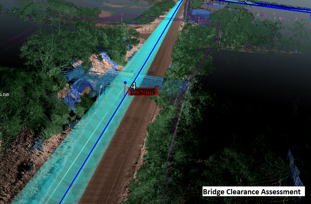
- Infrastructure Development
When planning infrastructure projects such as roads, bridges, or tunnels, lidar systems are used to assess the land, monitor changes, and plan construction. The high accuracy of lidar data helps engineers make informed decisions about the best placement of structures and how to minimise environmental impact.
Lidar vs Radar: Key Differences
Although lidar and radar are both remote sensing technologies, they work differently and serve distinct purposes. Here’s a comparison:
- Lidar uses light waves (lasers) to measure distances, while radar uses radio waves.
- Lidar offers much higher precision and resolution, which is ideal for detailed 3D mapping and modelling. Radar, on the other hand, excels in long-range detection and works well in adverse weather conditions like fog, rain, or snow.
- Lidar is commonly used for applications requiring precision, such as autonomous vehicles and geographical surveys, while radar is often used for air traffic control, weather forecasting, and maritime navigation.
Lidar Advantages Over Radar:
- Higher resolution and accuracy
- Better for short-range applications
- Ideal for creating 3D models
Choosing the Right Lidar Company for Your Needs
When investing in lidar solutions for your project, it’s crucial to choose the right lidar company. Not all lidar providers are equal, and the quality of the lidar system can significantly impact your project’s success. Here are some factors to consider when choosing a lidar company:
- Experience and Expertise
Look for a company with a proven track record in providing lidar technologies. A company with experience across a range of industries can help tailor the solution to your specific needs, whether it’s for autonomous vehicles, surveying, or environmental monitoring.
- Quality of Equipment
The quality of the lidar system itself is crucial for accuracy and reliability. Ensure that the lidar company you choose offers advanced, high-quality systems that meet your requirements.
- Software and Data Processing
The data processing and software used by the lidar company are equally important. Make sure that they offer robust software solutions that can process and analyse lidar data effectively, helping you make informed decisions based on accurate results.
- Customer Support
A good lidar company will provide excellent customer support and training to help you get the most out of your lidar system. Make sure the company offers ongoing technical support and assistance with data analysis.
At Lidar Solutions, we specialise in providing state-of-the-art lidar systems and services for a wide range of industries. Whether you’re in need of lidar solutions for autonomous vehicles, geographic mapping, or infrastructure planning, our team of experts is ready to provide tailored, high-precision results.
Why Choose Lidar Solutions for Your Lidar Needs?
When you partner with Lidar Solutions, you gain access to cutting-edge lidar technology designed for accuracy, efficiency, and reliability. Our expert team works closely with you to ensure that you get the best lidar solutions tailored to your specific requirements.
By choosing Lidar Solutions, you’re investing in high-quality equipment and professional services that will ensure your project’s success. From lidar surveying to autonomous vehicle development, we offer the most advanced lidar technologies available.
Explore our website and discover how lidar solutions can transform your business. Contact us today for a consultation and find out how we can assist you with your lidar needs.
Conclusion
In this comprehensive guide, we’ve covered the essentials of lidar technology, its core components, key applications, and the differences between lidar vs radar. We’ve also explored how we can provide the right lidar solutions for your needs.
If you’re ready to take your projects to the next level, Lidar Solutions is here to provide expert advice and high-quality lidar technology. Visit Lidar Solutions today to learn more and start your journey with precision lidar technology.