
Revolutionize Your Forestry Management with Advanced LiDAR Surveying
Welcome to the future of forestry survey and resource management. Our specialized LiDAR forestry services provide unprecedented accuracy, efficiency, and depth of insight for forest managers, conservationists, timber companies, and government agencies. We employ both aerial LiDAR survey (from drones or aircraft) and ground-based SLAM LiDAR scanning to deliver a complete picture of your forest assets. This multi-platform approach ensures that no detail is missed, from the forest floor to the top of the canopy.
What can we do with LiDAR data in forestry industry?
LIDAR data can be used to calculate individual tree characteristics
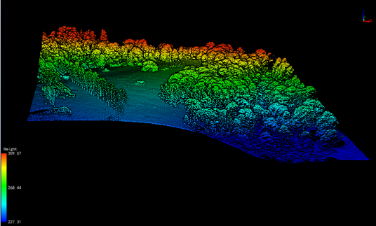
Lidar data has been claimed to be able to determine individual tree characteristics such as size, shape and height. This technology is useful for forestry surveying, habitat management and selective harvesting practices. Moreover, it can provide three-dimensional information about a target area, like Canopy Height Model (CHM).
And, because of the evolution of the AI based algorithm, the accuracy of determining a number of features such as tree count, species identification or volume is also improving. For example, the ALS and TLS module of LiDAR360 software can achieve reasonable accuracy for tree segmentation, tree locations and tree charecteristics.
The first pulse return of Lidar data measures the elevations of the canopy. This is one of the most important LiDAR features. It can help in distinguishing the forest canopy from the bare ground. Another important feature of Lidar is the mean of the first echo intensity. This is useful for reducing multiple scattering effects in discrete echo systems.
LIDAR data is used in environmental assessment
In environmental assessment, LIDAR data is used to determine the vertical structure of a forest canopy. It also gives information about the number and health of trees and foliage. This information is useful for forest planning and forest fire management. LiDAR is a laser-based technology that uses pulsed light waves to collect 3D representations of environments.
LiDAR sensors are equipped on multi-rotor fixed-wing or helicopter aircraft. They are capable of measuring the distances between the Earth and objects and transmitting the data to a GPS receiver. The data can be processed into a 3D point cloud, which is then used to create an image of the target environment.
LIDAR data can be used for a variety of purposes, including determining the amount of forest fire fuel, mapping pollutants, and estimating tree output. It can also be used to map the location of watershed boundaries and determine the health of a forest.
Several studies have investigated the derivation of biophysical properties from airborne lidar data. These studies focus on the use of different types of sensors, point density, and acquisition settings. Although the magnitude of the difference between point densities is very small, it has a significant effect on derived metrics. For instance, different point densities affect the size of the footprint.
Our LiDAR Solutions for forestry survey
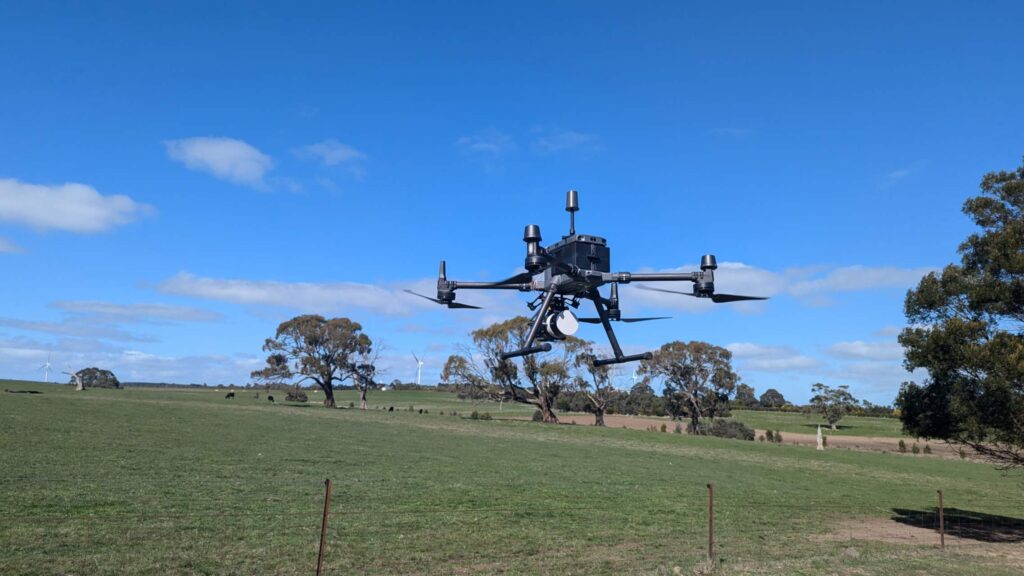
Aerial LiDAR Scanning
Aerial LiDAR (Light Detection and Ranging) is a remote sensing technology that uses lasers to scan the surface of the earth from an aircraft, such as drone, UAV, airplane or helicopter. In the context of forestry, LiDAR can be used to create high-resolution maps of the forest canopy with following benefits:
Rapid Large-Area Coverage: Survey thousands of hectares in a single flight, making it the most efficient method for regional inventories.
Superior Canopy & Topography Mapping: Perfect for capturing overall canopy height, closure, and landscape-scale terrain models.
Access to Inaccessible Areas: Safely map steep slopes, wetlands, and hazardous terrain without ground crew access.
Ideal for Biomass & Carbon Projects: Provides the consistent, landscape-level data required for large-scale carbon stock quantification.
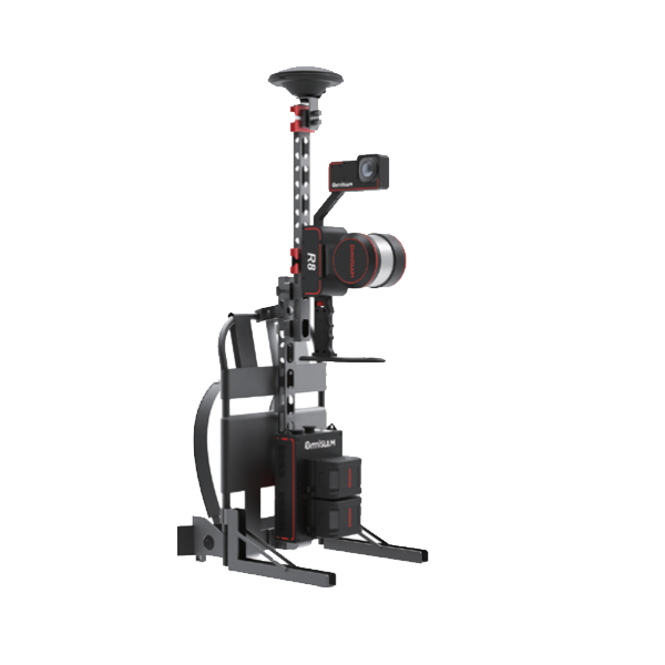
SLAM LiDAR Scanning Backpack/Handheld
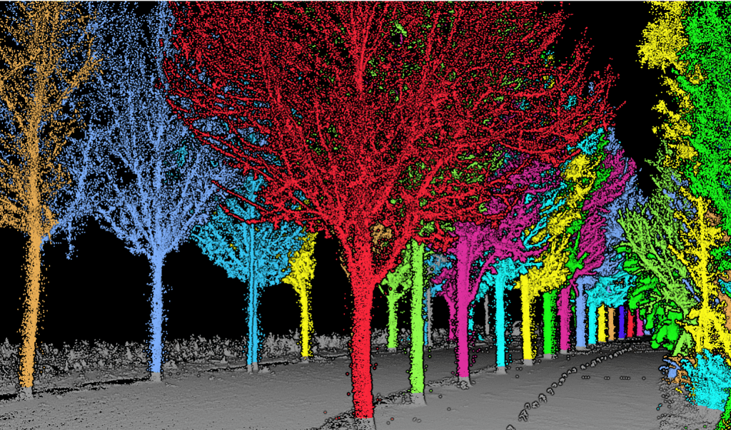
SLAM LiDAR scanning with backpack and handheld LiDAR scanners is an effective technique for acquiring detailed tree attributes in forest plots. Comparing to traditional laser scanning, it is much faster and can acquire high precision data for calculation of tree charectoristics such as height and a number of other tree attributes can be measured using a terrestrial laser scanner. These include aboveground biomass, leaf area index, and basal area. By combining these metrics, you can obtain a more accurate estimate of your forest’s total structural metric. You can also use these metrics to estimate tree attributes at a stand-level:
Unmatched Ground-Level Detail: Capture intricate understory vegetation, sapling counts, coarse woody debris, and precise tree trunk morphology.
Operates in GNSS-Denied Environments: SLAM technology excels in dense canopy cover where satellite signals (GPS) are weak or blocked.
High Precision in Complex Terrain: Ideal for detailed surveys of ravines, stream banks, research plots, and post-harvest site assessments.
Fuses with Aerial Data: Seamlessly integrates with aerial point clouds to create a complete, “bare-earth-to-treetop” digital twin of the forest.
Combined Advantage: Using both methods provides the ultimate forestry mapping solution—aerial data delivers the broad-scale context and metrics, while SLAM data fills in the critical ground-truth details, ensuring your decisions are based on the most comprehensive dataset possible.
Contact Us - NZ
What can we deliver to our client?
When you partner with us for your forestry LiDAR survey, you receive more than just data—you receive clear, user-friendly insights tailored to your decision-making needs. Our deliverables are tailored to the scanning method used to meet your specific project goals.
High-Density 3D Point Clouds
The raw, classified data (ground, vegetation, buildings) from aerial or SLAM LiDAR for use in GIS and specialized forestry software.
Canopy Height Models (CHM) & Digital Terrain Models (DTM)
Essential raster layers for analyzing forest structure and ground surface, primarily derived from airborne LiDAR.
Detailed Understory Models
High-resolution 3D models of forest floor conditions, ideal for biodiversity studies, delivered from SLAM LiDAR scanning.
Detailed Inventory Reports
Summaries of tree counts, height distributions, basal area, and volume estimates by designated strata or compartments.
Biomass and Carbon Stock Maps
Thematic maps visualizing the spatial distribution of biomass and estimated carbon storage across your property.
Contour Maps and Slope Analysis
Critical layers for operational planning, road engineering, and erosion risk assessment.
GIS-Ready Formats
All data delivered in standard formats (e.g., .las, .tiff, .shp, .kml) compatible with platforms like ArcGIS, QGIS, and AutoCAD.
Expert Consultation & Method Recommendation
We guide you on the optimal approach—aerial, SLAM, or an integrated survey—and provide expert interpretation of the results.