
What is Lidar and How Does It Work? - NZ
In today’s fast-moving digital world, gathering accurate information about our surroundings has become crucial across almost every industry. One incredible innovation leading this transformation is lidar technologies. But what is lidar exactly, and why is it considered one of the most powerful mapping and measurement tools available? Lidar, which stands for Light Detection and Ranging, uses laser light to precisely measure distances, creating detailed 3D representations of objects and landscapes. Whether it’s helping self-driving cars navigate safely, assisting environmental scientists in monitoring forests, or enabling engineers to design smart cities, what is lidar technology is reshaping the way we understand and interact with the world. In this guide, we’ll explore the basics of Lidar, how it works, the core components involved, and the many industries it is revolutionising — all while showing why it continues to stand out as a game-changer in modern technology.
What is Lidar?
Lidar, short for Light Detection and Ranging, is a remote sensing method that uses laser light to measure distances. It works similarly to how bats navigate using sound, except lidar technologies use lasers to “see” their surroundings with incredible detail.
The process is simple yet powerful: thousands of laser pulses are sent out every second, bounce off objects, and return to the sensor. By calculating the time each pulse takes to come back, a precise 3D map of the environment is created.
When people ask, “what is lidar?” — it’s much more than a concept. It’s an advanced technology powering everything from self-driving cars to environmental conservation efforts.
Thanks to lidar technologies, businesses, researchers, and engineers can access real-time, highly accurate data to make smarter decisions.
Key Components of Lidar Technologies
Understanding what is lidar technology means knowing about the essential parts that work together to achieve remarkable results:
- Laser Source
At the heart of lidar technologies is the laser source. It emits focused beams of light that travel toward a target. Different systems may use ultraviolet, visible, or infrared wavelengths depending on the application.
Using high-quality laser sources ensures that Lidar can measure large areas quickly and accurately, even across complex terrains. Choosing the right laser wavelength is crucial because it determines how deeply the laser can penetrate materials like vegetation, fog, or dust — making what is lidar an adaptable tool for diverse environments.
- Scanner and Optics
The scanner system moves the laser beam across the landscape or object. Mirrors and rotating devices allow lidar technologies to capture huge volumes of data in minutes.
Advanced optics ensure that the laser covers wide areas without missing small details, delivering comprehensive results even in large-scale projects. With rapid scanning abilities, what is lidar technology becomes ideal for projects like road surveying, urban planning, and forestry management.
- Photodetector
After bouncing off an object, the laser light returns to the sensor. The photodetector captures this reflected light and accurately measures the time of flight.
High-speed photodetectors in lidar technologies ensure that even tiny time differences are recorded, enabling extremely fine measurements. Thanks to precise detectors, what is lidar can create accurate digital twins of real-world spaces.
- Position and Navigation Systems
To ensure the collected data is geographically accurate, Lidar systems rely on Global Positioning Systems (GPS) and Inertial Measurement Units (IMUs).
These systems track the position and movement of the Lidar sensor in real time. Without GPS and IMUs, mapping large areas would not be nearly as accurate. Positioning components make what is lidar technology a reliable choice for everything from aerial surveys to autonomous vehicle navigation.
How Does Lidar Work?
The beauty of lidar technologies lies in their simple yet powerful method of data collection:
Step 1: Emission
The laser source emits rapid pulses of light, sometimes up to a million pulses per second, toward the target area.
Step 2: Reflection
These light pulses strike objects — such as trees, buildings, vehicles — and reflect back to the sensor.
Step 3: Calculation
The system calculates how long each pulse took to return. Knowing the speed of light allows for easy and highly accurate distance measurements.
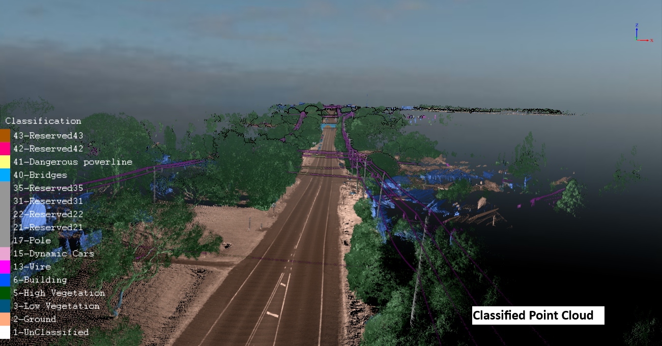
Step 4: Point Cloud Creation
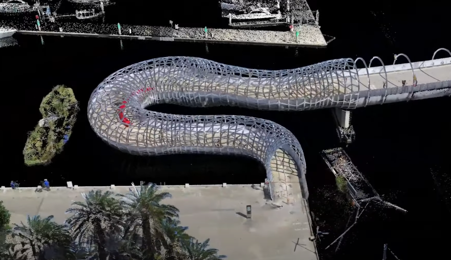
Millions of individual distance measurements are combined into a dense “point cloud,” forming a detailed 3D representation of the environment.
This entire process happens in real-time, allowing lidar technologies to capture the world as it is — precisely and instantly.
Why Lidar Technologies Are Exceptionally Accurate
Understanding what is lidar technology means knowing about the essential parts that work together to achieve remarkable results:
- Laser Source
At the heart of lidar technologies is the laser source. It emits focused beams of light that travel toward a target. Different systems may use ultraviolet, visible, or infrared wavelengths depending on the application.
Using high-quality laser sources ensures that Lidar can measure large areas quickly and accurately, even across complex terrains. Choosing the right laser wavelength is crucial because it determines how deeply the laser can penetrate materials like vegetation, fog, or dust — making what is lidar an adaptable tool for diverse environments.
- Scanner and Optics
The scanner system moves the laser beam across the landscape or object. Mirrors and rotating devices allow lidar technologies to capture huge volumes of data in minutes.
Advanced optics ensure that the laser covers wide areas without missing small details, delivering comprehensive results even in large-scale projects. With rapid scanning abilities, what is lidar technology becomes ideal for projects like road surveying, urban planning, and forestry management.
- Photodetector
After bouncing off an object, the laser light returns to the sensor. The photodetector captures this reflected light and accurately measures the time of flight.
High-speed photodetectors in lidar technologies ensure that even tiny time differences are recorded, enabling extremely fine measurements. Thanks to precise detectors, what is lidar can create accurate digital twins of real-world spaces.
- Position and Navigation Systems
To ensure the collected data is geographically accurate, Lidar systems rely on Global Positioning Systems (GPS) and Inertial Measurement Units (IMUs).
These systems track the position and movement of the Lidar sensor in real time. Without GPS and IMUs, mapping large areas would not be nearly as accurate. Positioning components make what is lidar technology a reliable choice for everything from aerial surveys to autonomous vehicle navigation.
Industries Benefiting from Lidar Technologies
Thanks to its versatility, lidar technologies are making a huge impact across many sectors:
- Autonomous Vehicles
Self-driving cars use Lidar to detect objects, map surroundings, and safely navigate through traffic. Without Lidar, reliable autonomous navigation would be much harder to achieve.
- Environmental Studies
Researchers use Lidar to monitor changes in forests, rivers, glaciers, and coastlines. The precision of what is lidar allows scientists to track changes over time with incredible accuracy.
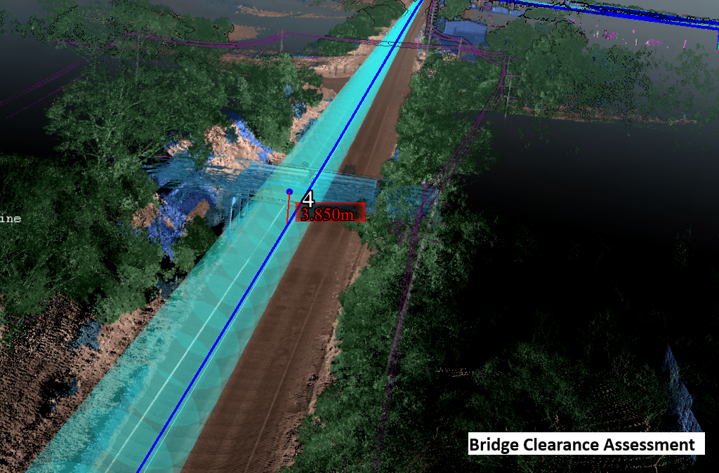
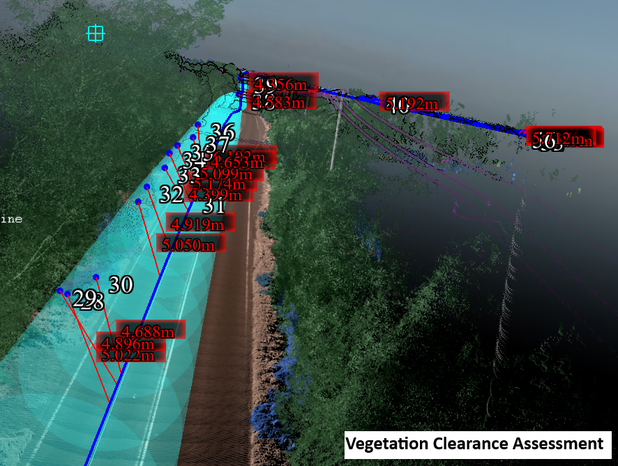
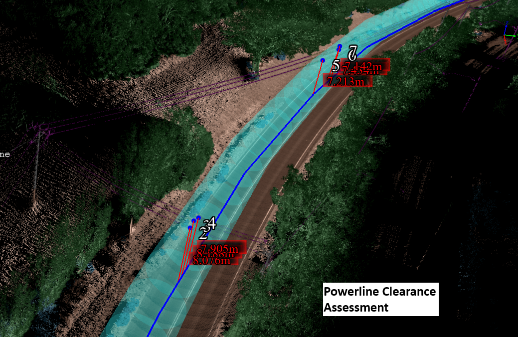
- Construction and Infrastructure
Construction projects use Lidar for pre-construction surveys, progress monitoring, and quality control. Engineers rely on what is lidar technology to ensure projects are built precisely to plan.
- Agriculture
Modern farming has been transformed by Lidar. Farmers use Lidar to map field topography, optimise irrigation, and increase yields while minimising waste.
- Archaeology
Hidden ruins and ancient cities are being uncovered with Lidar, revealing treasures beneath dense vegetation without the need for excavation.
- Mining
Mining companies use lidar technologies to survey sites, manage excavation operations, and monitor land stability for safety.
Different Types of Lidar Systems
Understanding what is lidar technology includes knowing the different types of systems available:
Airborne Lidar
Airborne Lidar systems are mounted on drones, helicopters, or airplanes. They cover large areas quickly and are ideal for environmental monitoring, urban planning, and disaster management.
Terrestrial Lidar
Terrestrial Lidar is used on the ground and can be fixed to tripods, moving vehicles, or handheld devices. It’s perfect for detailed site surveys, construction management, and heritage preservation projects.
Both types offer unique advantages depending on the project’s goals — and both showcase the versatility of lidar technologies.
The Bright Future of Lidar Technologies
The future looks incredibly promising for lidar technologies. New developments like solid-state Lidar — with no moving parts — are making sensors cheaper, smaller, and even more durable.
As innovation continues, what is lidar technology will become even more integrated into our daily lives, from smarter cities to better public transportation systems.
Expect to see Lidar used more in healthcare, retail, augmented reality, and other sectors — creating opportunities we’ve only just begun to imagine.
FAQs About Lidar Technologies
What is Lidar used for?
Lidar is used for mapping, surveying, environmental monitoring, construction, and autonomous vehicle navigation.
Is Lidar accurate?
Yes, lidar technologies offer centimetre-level accuracy, making them some of the most reliable mapping tools available.
Can Lidar work in darkness?
Absolutely. Since Lidar uses light pulses, it works efficiently at night and in low-light conditions.
How affordable is Lidar?
As technology improves, what is lidar is becoming more affordable and accessible across industries.
Who uses Lidar?
Industries such as automotive, agriculture, mining, construction, archaeology, and environmental science heavily rely on lidar technologies.
Final Thoughts
As you can see, understanding what is lidar is key to appreciating the incredible role it plays across countless industries today. From autonomous vehicles that rely on real-time data to navigate safely, to farmers optimising their crops with precise land measurements, to researchers uncovering ancient civilisations hidden beneath dense forests — the potential of lidar technologies is limitless. By providing fast, accurate, and reliable environmental data, what is lidar technology is helping build a smarter, safer, and more connected world. As innovation continues and Lidar systems become even more accessible, their influence will only grow stronger across industries. If you’re looking to harness the incredible benefits of Lidar for your next project, there’s no better time to partner with the experts at Lidar Solutions. Discover how you can elevate your operations and unlock new possibilities with cutting-edge Lidar technology today.